

What causes a tsunami? An ocean scientist explains the physics of these destructive waves

Assistant Professor of Climate Science, Brandeis University
Disclosure statement
Sally Warner has received funding from the National Science Foundation and the Office of Naval Research.
Brandeis University provides funding as a member of The Conversation US.
View all partners
On Jan. 15, 2022, the Hunga Tonga-Hunga Ha’apai volcano in Tonga erupted, sending a tsunami racing across the Pacific Ocean in all directions.
As word of the eruption spread, government agencies on surrounding islands and in places as far away as New Zealand, Japan and even the U.S. West Coast issued tsunami warnings. Only about 12 hours after the initial eruption, tsunami waves a few feet tall hit California shorelines – more than 5,000 miles away from the eruption.
I’m a physical oceanographer who studies waves and turbulent mixing in the ocean. Tsunamis are one of my favorite topics to teach my students because the physics of how they move through oceans is so simple and elegant.
Waves that are a few feet tall hitting a beach in California might not sound like the destructive waves the term calls to mind, nor what you see in footage of tragic tsunamis from the past . But tsunamis are not normal waves, no matter the size. So how are tsunamis different from other ocean waves? What generates them? How do they travel so fast? And why are they so destructive?
Deep displacement
Most waves are generated by wind as it blows over the ocean’s surface, transferring energy to and displacing the water. This process creates the waves you see at the beach every day.
Tsunamis are created by an entirely different mechanism. When an underwater earthquake, volcanic eruption or landslide displaces a large amount of water, that energy has to go somewhere – so it generates a series of waves. Unlike wind-driven waves where the energy is confined to the upper layer of the ocean, the energy in a series of tsunami waves extends throughout the entire depth of the ocean. Additionally, a lot more water is displaced than in a wind-driven wave.
Imagine the difference in the waves that are created if you were to blow on the surface of a swimming pool compared to the waves that are created when someone jumps in with a big cannonball dive. The cannonball dive displaces a lot more water than blowing on the surface, so it creates a much bigger set of waves.
Earthquakes can easily move huge amounts of water and cause dangerous tsunamis. Same with large undersea landslides. In the case of the Tonga tsunami, the massive explosion of the volcano displaced the water. Some scientists are speculating that the eruption also caused an undersea landslide that contributed to the large amount of displaced water. Future research will help confirm whether this is true or not.
Tsunami waves travel fast
No matter the cause of a tsunami, after the water is displaced, waves propagate outward in all directions – similarly to when a stone is thrown into a serene pond.
Because the energy in tsunami waves reaches all the way to the bottom of the ocean, the depth of the sea floor is the primary factor that determines how fast they move. Calculating the speed of a tsunami is actually quite simple. You just multiply the depth of the ocean – 13,000 feet (4,000 meters) on average – by gravity and take the square root. Doing this, you get an average speed of about 440 miles per hour (700 kilometers per hour). This is much faster than the speed of typical waves, which can range from about 10 to 30 mph (15 to 50 kph).
This equation is what oceanographers use to estimate when a tsunami will reach faraway shores. The tsunami on Jan. 15 hit Santa Cruz, California, 12 hours and 12 minutes after the initial eruption in Tonga. Santa Cruz is 5,280 miles (8,528 kilometers) from Tonga, which means that the tsunami traveled at 433 mph (697 kph) – nearly identical to the speed estimate calculated using the ocean’s average depth.

Destruction on land
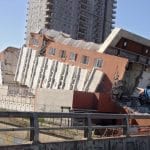
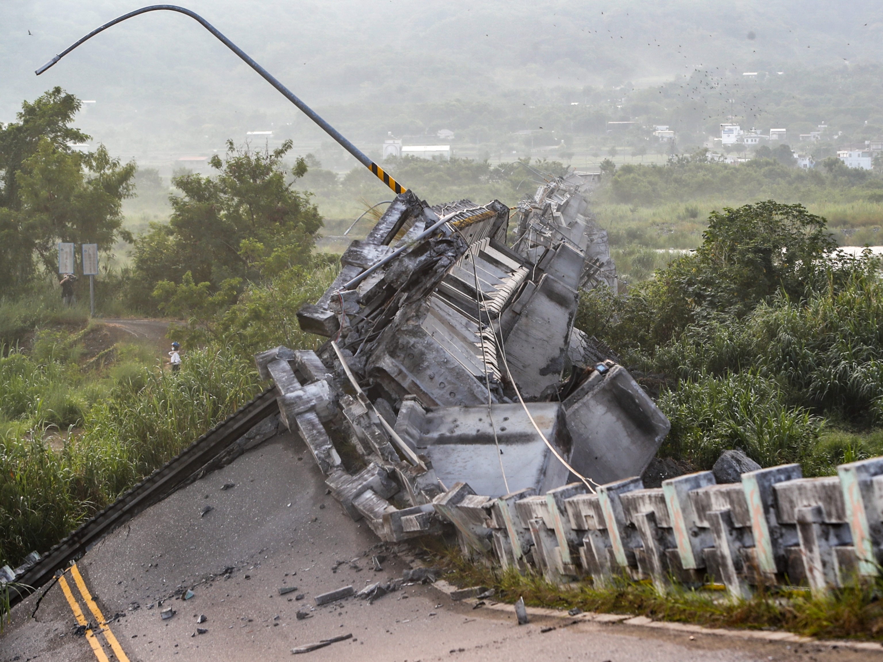
Tsunamis are rare compared to ubiquitous wind-driven waves, but they are often much more destructive. The 2004 Indian Ocean tsunami killed 225,000 people. More than 20,000 lost their lives in the 2011 Japan tsunami.
What makes tsunamis so much more destructive than normal waves?
In the open ocean, tsunami waves can be small and may even be undetectable by a boat at the surface. But as the tsunami approaches land, the ocean gets progressively shallower and all the wave energy that extended thousands of feet to the bottom of the deep ocean gets compressed. The displaced water needs to go somewhere. The only place to go is up, so the waves get taller and taller as they approach shore.
When tsunamis get to shore, they often do not crest and break like a typical ocean wave. Instead, they are more like a large wall of water that can inundate land near the coast. It is as if sea level were to suddenly rise by a few feet or more. This can cause flooding and very strong currents that can easily sweep people, cars and buildings away.
[ Get fascinating science, health and technology news. Sign up for The Conversation’s weekly science newsletter .]
Luckily, tsunamis are rare and not nearly as much of a surprise as they once were. There is now an extensive array of bottom pressure sensors, called DART buoys , that can sense a tsunami wave and allow government agencies to send warnings prior to the arrival of the tsunami.
If you live near a coast – especially on the Pacific Ocean where the vast majority of tsunamis occur – be sure to know your tsunami escape route for getting to higher ground, and listen to tsunami warnings if you receive one.
The eruption of the Hunga Tonga-Hunga Ha’apai volcano severed the main communication cable that connects the people of Tonga to the rest of the world. While the science of tsunamis can be fascinating, these are serious natural disasters. Only a few deaths have been reported so far from Tonga, but many people are missing and the true extent of the damage from the tsunami is still unknown.
- Earthquakes
- Pacific Ocean
- Tsunami warning
Deputy Social Media Producer
Research Fellow /Senior Research Fellow – Implementation Science
Associate Professor, Occupational Therapy
GRAINS RESEARCH AND DEVELOPMENT CORPORATION CHAIRPERSON
Faculty of Law - Academic Appointment Opportunities

The Science of Tsunamis

The word “tsunami” brings immediately to mind the havoc that can be wrought by these uniquely powerful waves. The tsunamis we hear about most often are caused by undersea earthquakes, and the waves they generate can travel at speeds of up to 250 miles per hour and reach tens of meters high when they make landfall and break. They can cause massive flooding and rapid widespread devastation in coastal areas, as happened in Southeast Asia in 2004 and in Japan in 2011.
But significant tsunamis can be caused by other events as well. The partial collapse of the volcano Anak Krakatau in Indonesia in 2018 caused a tsunami that killed more than 400 people. Large landslides, which send immense amounts of debris into the sea, also can cause tsunamis. Scientists naturally would like to know how and to what extent they might be able to predict the features of tsunamis under various circumstances.
Most models of tsunamis generated by landslides are based on the idea that the size and power of a tsunami is determined by the thickness, or depth, of the landslide and the speed of the “front” as it meets the water. In a paper titled “Nonlinear regimes of tsunami waves generated by a granular collapse,” published online in the Journal of Fluid Mechanics, UC Santa Barbara mechanical engineer Alban Sauret and his colleagues, Wladimir Sarlin, Cyprien Morize and Philippe Gondret at the Fluids, Automation and Thermal Systems (FAST) Laboratory at the University of Paris-Saclay and the French National Centre for Scientific Research (CNRS), shed more light on the subject. (The article also will appear in the journal’s July 25 print edition.)
This is the latest in a series of papers the team has published on environmental flows, and on tsunami waves generated by landslides in particular. Earlier this year, they showed that the velocity of a collapse — i.e., the rate at which the landslide is traveling when it enters the water — controls the amplitude, or vertical size, of the wave.
In their most recent experiments, the researchers carefully measured the volume of the granular material, which they then released, causing it to collapse as a cliff would, into a long, narrow channel filled with water. They found that while the density and diameter of the grains within a landslide had little effect on the amplitude of the wave, the total volume of the grains and the depth of the liquid played much more crucial roles.

A photograph of an experimental lab setup reflecting the fluid dynamics of a tsunami
Photo Credit: ILLUSTRATION COURTESY OF FAST AND UC SANTA BARBARA
“As the grains enter the water, they act as a piston, the horizontal force of which governs the formation of the wave, including its amplitude relative to the depth of the water,” said Sauret. (A remaining challenge is to understand what governs the speed of the piston.) “The experiments also showed that if we know the geometry of the initial column [the material that flows into the water] before it collapses and the depth of the water where it lands, we can predict the amplitude of the wave.”
The team can now add this element to the evolving model they have developed to couple the dynamics of the landslide and the generation of the tsunami. A particular challenge is to describe the transition from an initial dry landslide, when the particles are separated by air, to an underwater granular flow, when the water has an important impact on particle motion. As that occurs, the forces acting on the grains change drastically, affecting the velocity at which the front of grains that make up the landslide enters the water.
Currently, there is a large gap in the predictions of tsunamis based on simplified models that consider the field complexity (i.e., the geophysics) but do not capture the physics of the landslide as it enters the water. The researchers are now comparing the data from their model with data collected from real-life case studies to see if they correlate well and if any field elements might influence the results.
Share this article
About UC Santa Barbara
The University of California, Santa Barbara is a leading research institution that also provides a comprehensive liberal arts learning experience. Our academic community of faculty, students, and staff is characterized by a culture of interdisciplinary collaboration that is responsive to the needs of our multicultural and global society. All of this takes place within a living and learning environment like no other, as we draw inspiration from the beauty and resources of our extraordinary location at the edge of the Pacific Ocean.
Related Stories

April 16, 2024
Computer scientist William Wang receives prestigious early career technical achievement award

April 11, 2024
Five UC Santa Barbara undergraduates named Goldwater Scholars

Whale-saving cargo ship speed tracking program heads east

April 10, 2024
UC Santa Barbara researchers launch CoastSnap, citizen science initiative to monitor coastal changes

- Previous Messages
- Message Subscriptions
- Message Definitions
- Product List
- Tsunami Event XML (TEX)
- DART Systems
- NOAA Coastal Water-Level Stations
- International
- Historical Tsunamis
- Recent Tsunamis
- Tsunami FAQ
- Tsunami Safety
- Tsunami Education and Outreach
- NOAA Tsunami Program
- TsunamiReady
- International Tsunami Information Center
- Caribbean Tsunami Warning Program
- Tsunami Research
- National Tsunami Hazard Mitigation Program
- IOC/UNESCO Tsunami Program
- About the Warning Centers
- Canada/US except Hawaii
- American Samoa
- Puerto Rico/Virgin Islands
- International Pacific
- International Caribbean
- Visit a Warning Center

While distant tsunamis pose a threat to all U.S. coasts, the hazard is greatest for coastlines near subduction zones, where large earthquakes and associated landslides can produce damaging waves that threaten nearby and distant coasts, like those around the Pacific and Caribbean. The U.S. East and Gulf Coasts are not near subduction zones, and earthquakes are not as large or as frequent as in other regions. The most likely sources of tsunamis on these coasts are underwater landslides and meteotsunamis.
The tsunami hazard level for Anchorage and the upper Cook Inlet is very low when compared to the Southern Coast of Alaska. When tsunamis enter the upper Cook Inlet from the Gulf of Alaska or the lower Cook Inlet, they are weakened by the relatively shallow water of the upper Cook Inlet to a point that they are no longer dangerous.
There is no season for tsunamis. A tsunami can happen any time, any season, and during any weather.
There are a number of online resources that can provide more information about tsunamis. Key resources include the following:
- The COMET Program’s Tsunami Distance Learning Course (six independent modules)
- National Weather Service’s JetStream Online Weather School (tsunami module)
- National Weather Service’s Tsunami Safety website
- Global Historical Tsunami Database
- The TsunamiZone
2. Causes of a Tsunami
A tsunami is caused by a large and sudden displacement of the ocean. Large earthquakes below or near the ocean floor are the most common cause, but landslides, volcanic activity, certain types of weather, and near earth objects (e.g., asteroids, comets) can also cause tsunamis. Most of the tsunamis (88%) in the Global Historical Tsunami Database were generated by earthquakes or landslides caused by earthquakes.
Earthquakes provide the energy to generate tsunamis through sudden movements to the water column. Key earthquake characteristics that contribute to tsunami generation are location, magnitude, and depth. Most tsunamis are generated by earthquakes with magnitudes over 7.0 that occur under or very near the ocean (usually at or near subduction zones, where oceanic and continental plates collide) and less than 100 kilometers (62 miles) below the Earth’s surface. Generally, an earthquake must exceed magnitude 8.0 to generate a dangerous distant tsunami.
An earthquake must be big enough and close enough to the ocean floor to cause the vertical movement of the ocean floor that typically sets a tsunami in motion. As the ocean floor rises or drops, so too does the water above it. As the water moves up and down, seeking to regain its balance, the tsunami radiates out in all directions. The amount of movement of the ocean floor, the size of the area over which it occurs (which may be reflected in how long the earthquake lasts), and the depth of the water at its source are all important factors in the size of a resulting tsunami. Earthquakes can also cause landslides that generate tsunamis.
Examples of earthquake-generated tsunamis:
- March 11, 2011 Honshu Island, Japan (video)—A magnitude 9.1 earthquake generated a tsunami that caused tremendous devastation locally and was observed all over the Pacific. In Japan, the earthquake and tsunami displaced more than 500,000 people, caused approximately $236 billion (2016 dollars) in damage and resulted in a nuclear accident. Most of the 18,457 deaths were due to the tsunami. Along the coast of Japan, tsunamis reached 128 feet high and almost five miles inland. Outside Japan there was very little loss of life due to warnings and evacuations, but in the United States there was more than $91 million in damage and one death. This event is the most expensive natural disaster in history.
- December 26, 2004 Northern Sumatra, Indonesia (animation)—A magnitude 9.1 earthquake generated the deadliest tsunami in history. The tsunami was responsible for the majority of the impacts, which were observed in 15 countries in Southeastern and Southern Asia and Eastern and Southern Africa. Impacts included approximately 230,000 deaths, the displacement of 1.7 million people, and roughly $13 billion (2016 dollars) in economic losses. On the northern coast of Sumatra, waves reached up to 167 feet high and traveled as far as three miles inland. The extent of the losses can be attributed in part to the lack of an official tsunami warning system in the Indian Ocean at the time and limited knowledge about tsunamis.
- March 27, 1964 Prince William Sound, Alaska (animation)—A magnitude 9.2 earthquake (the largest recorded in U.S. history) generated a number of tsunamis that devastated coastal communities in Alaska with waves as high as 167 feet (and a 220 foot splash mark) and caused damage along the west coasts of the United States and Canada and in Hawaii. Tsunami damage was approximately $1 billion (2016 dollars). About 124 deaths were caused by the tsunami. NOAA’s National Tsunami Warning Center was established in response to this tsunami.
- April 1, 1946 Aleutian Islands, Alaska (animation)—A magnitude 8.6 earthquake generated a tsunami that was destructive across the Pacific. Most of the 167 lives lost and $322 million (2016 dollars) in damage were in Hawaii where waves reached as high as 55 feet. NOAA’s Pacific Tsunami Warning Center was established in response to this tsunami.
- November 1, 1755 Lisbon, Portugal (animation)—A magnitude 8.5 (estimated) earthquake in the Atlantic Ocean generated a tsunami that affected the coasts of Portugal, Spain, North Africa, and the Caribbean. The earthquake and tsunami killed an estimated 50,000 people and caused widespread destruction.
- January 26, 1700 Cascadia Subduction Zone (animation)—A magnitude 9.0 (estimated) earthquake generated a tsunami that inundated the coasts of Cascadia (a region that includes northern California, Oregon, Washington, and southern British Columbia) as well as coastal villages on the other side of the Pacific Ocean in Japan. Today, the Cascadia Subduction Zone is considered one of the largest U.S. tsunami threats.
Source: Global Historical Tsunami Database
To learn more about earthquakes, visit the U.S. Geological Survey’s Earthquake Hazards Program.
Most of the earthquakes that generate tsunamis occur on thrust or reverse faults. These earthquakes originate mainly where tectonic plates move toward each other in subduction zones. But, 10-15 percent of damaging tsunamis are generated by strike-slip earthquakes, where the movement of the earth is horizontal. These tsunamis are likely generated by associated landslides, movement of a sloping ocean floor, or the presence of seamounts, which are underwater mountains (that can act like paddles and push the water horizontally). Tsunamis generated by strike-slip earthquakes normally affect regions near the source only.
To learn more about faults, visit the visual glossary from the U.S. Geology Survey.
The largest earthquake ever recorded was a magnitude 9.5 earthquake off the coast of Southern Chile on May 22, 1960. This earthquake and the second largest earthquake, the 1964 magnitude 9.2 in Prince William Sound, Alaska, both generated devastating tsunamis.
Learn more about past earthquakes from the U.S. Geological Survey.
Relating to tsunami generation, “landslide” is a general term that incorporates a number of types of ground movement, including rock falls, slope failures, debris flows, slumps, ice falls/avalanches, and glacial calving (the breaking off of large pieces of ice from a glacier). Tsunamis can be generated when a landslide enters the water and displaces it from above (subaerial) or when water is displaced ahead of and behind an underwater (submarine) landslide. Tsunami generation depends on the amount of landslide material that displaces the water, the speed it is moving, and the depth it moves to. Landslide-generated tsunamis may be larger than seismic tsunamis near their source and can impact coastlines within minutes with little to no warning, but they usually lose energy quickly and rarely affect distant coastlines.
Most landslides that generate tsunamis are caused by earthquakes, but other forces (like gravity, wind, and increased precipitation) can cause overly steep and otherwise unstable slopes to suddenly fail. Earthquakes that are not large enough to directly generate a tsunami may be large enough to cause a landslide that in turn can generate a tsunami. A landslide-generated tsunami may occur independently or along with a tsunami directly generated by an earthquake, which can complicate the warning process and compound the losses.
- July 17, 1998 Papua New Guinea —A moderately sized magnitude 7.0 earthquake triggered a large underwater landslide that generated a deadly tsunami. Three waves, the highest measuring roughly 49 feet high, struck the coast within 20 minutes of the earthquake, destroying entire villages. Approximately 2,200 lives were lost, and more than 10,000 people were displaced.
- July 10, 1958 Southeast Alaska —A magnitude 7.8 earthquake triggered a number of submarine landslides, rock falls, and ice falls that generated tsunamis that killed five people. A rock fall into Lituya Bay sent water surging over the opposite shore, clearing trees around the bay up to a maximum height of 1,720 feet. It is considered the largest tsunami ever recorded.
- November 18, 1929 Grand Banks, Newfoundland, Canada —A magnitude 7.3 earthquake in the Atlantic Ocean triggered a submarine landslide that generated a tsunami. Waves up to 43 feet high were responsible for 28 deaths and $14 million (2016 dollars) in damage along the coast of Newfoundland.
To learn more about landslides, visit the U.S. Geological Survey’s Landslide Hazards Program .
Tsunamis generated by volcanoes, both above and below water, are infrequent, but several types of volcanic activity can displace enough water to generate destructive tsunamis. These include:
- Pyroclastic flows (flowing mixtures of rock fragments, gas, and ash)
- Submarine explosions relatively near the ocean surface
- Caldera formation (volcanic collapse)
- Landslides (e.g., flank collapse, debris flows)
- Lateral blasts (sideways eruptions)
Like other nonseismic tsunamis, such as those generated by landslides, volcanic tsunamis usually lose energy quickly and rarely affect distant coastlines.
Examples of volcano-generated tsunamis:
- August 27, 1883 Indonesia —The volcano Krakatau (Krakatoa) exploded and collapsed, generating one of the largest and most destructive tsunamis ever recorded. Waves reaching 135 feet high destroyed coastal towns and villages along the coasts of Java and Sumatra and killed more than 34,000 people.
- May 21, 1792 Kyushu Island, Japan —At the end of the four-month eruption of the Unzen volcano, a flank collapse generated a tsunami with waves reaching 180 feet high that caused destruction around the Ariake Sea and more than 14,000 deaths.
- ~1610 BC Greece —The volcano Santorini (Thera) erupted, generating a tsunami that swept the shores of nearby islands and contributed to the end of the Minoan culture on the nearby island of Crete.
To learn more about volcanoes, visit the U.S. Geological Survey’s Volcano Hazards Program .
Air pressure disturbances often associated with fast moving weather systems, like squall lines, can generate tsunamis. These “meteotsunamis” are similar to tsunamis generated by earthquakes. Their development depends on the intensity, direction, and speed of the air pressure disturbance as it travels over the ocean as well as the ocean’s depth. Meteotsunamis are regional, and certain parts of the world are prone to them due to a combination of factors such as local weather patterns and the shape and features of the surface of the Earth, both above and below the ocean.
- June 13, 2013 Northeastern United States (animation)—Tsunami-like waves crashed upon the New Jersey and southern Massachusetts coasts, despite clear skies and calm weather. In Barnegat Inlet, New Jersey, three people were injured when a six-foot wave swept them off a jetty and into the water. After ruling out other sources, scientists determined the waves had been generated by a derecho (a high-speed windstorm associated with a strong band of thunderstorms) that had passed through the area hours earlier.
- June 21, 1978 Vela Luka, Croatia —Without warning and during relatively nice weather, flooding waves inundated the port town of Vela Luka. Scientists ultimately identified the source as atmospheric and deemed it the strongest meteotsunami on record. This event featured 19.5-foot waves, lasted several hours, and caused millions of dollars in damage.
To learn more about meteotsunamis, read “ What Is a Meteotsunami? ”
It is very rare for a near earth object like an asteroid or comet to reach the earth, and there is still a lot of uncertainty about their potential to generate tsunamis and the size and reach of those tsunamis if they do. Scientists believe there are two ways near earth objects could generate a tsunami. Large objects (approximately 1,000 meters, 0.62 mile, or more in diameter) that make it through Earth’s atmosphere without burning up could hit the ocean, displacing water and generating an “impact” tsunami. Smaller objects tend to burn up in the atmosphere, exploding before they reach the Earth’s surface. If this happens above the ocean, the explosion could release energy into the ocean and generate an “airburst” tsunami.
Example of a near earth object tsunami: Evidence suggests that the Chicxulub impact on Mexico’s Yucatán Peninsula, which likely caused a mass extinction at the end of the Cretaceous period 65 million years ago, may have generated a tsunami that reached hundreds of miles inland around the Gulf of Mexico.
3. Tsunami Characteristics
A tsunami is a series of waves, not just one. These waves are often referred to as the tsunami wave train. A large tsunami may continue for days in some locations.
The speed of a tsunami depends on the depth of the water it is traveling through. The deeper the water; the faster the tsunami. In the deep ocean, tsunamis can move as fast as a jet plane, over 500 mph, and can cross entire oceans in less than a day. As the waves enter shallow water near land, they slow to the speed of a car, approximately 20 or 30 mph.
Tsunami speed can be computed by taking the square root of the product of the water depth and the acceleration of gravity (32.2 feet per second squared). In 15,000 feet of water, this works out to about 475 miles per hour. At rates like this, a tsunami will travel from the Aleutian Islands to Hawaii in about five hours; or from the Portugal coast to North Carolina in eight and a half hours.
In the deep ocean, the wavelength of a tsunami (the distance between waves) may be hundreds of miles, but its waves may be barely noticeable and are rarely more than three feet high. Mariners at sea will not normally notice tsunamis as they pass beneath their hulls. As the waves enter shallow water near land and slow down, their wavelengths decrease, they grow in height, and currents intensify. When they strike land, most tsunamis are less than 10 feet high, but in extreme cases, can exceed 100 feet when they strike near their source. The first wave may not be the last or the largest. A large tsunami can flood low-lying coastal areas more than a mile inland.
Not all tsunamis act the same, and an individual tsunami may affect coasts differently due to offshore and coastal features. Reefs, bays, entrances to rivers, undersea features, and the slope of the beach can all influence the size, appearance, and impact of tsunamis when they strike the coast. A small nondestructive tsunami in one place may be very large and violent a few miles away.
When a tsunami reaches the coast, it may look like a fast-rising flood, or a wall of water (bore). Its appearance may differ at different points along a coast. It will not look like a normal wind wave. Tsunamis rarely become great towering breaking waves. Sometimes, before the water rushes on land, it will suddenly recede, showing the ocean floor, reefs, and fish like a very low, low tide.
Large tsunamis may continue for days in some locations, reaching their peak often a couple of hours after arrival and gradually tapering off after that. The time between tsunami crests (the tsunami’s period) ranges from approximately five minutes to two hours. Dangerous tsunami currents can last for days.
Tsunamis are often referred to as local or distant. The type of tsunami depends on the location of the source of the tsunami and where it may strike land. The source of a local tsunami is close to the coast and may arrive in less than one hour. The danger is greatest for local tsunamis because warning time is limited. A distant tsunami is generated far away from a coast, so there is more time to issue and respond to warnings.
Most ocean waves are generated by wind. Tsunamis are not the same as wind waves. First of all, they have different sources. In addition, tsunamis move through the entire water column, from the ocean surface to the ocean floor, while wind waves only affect the ocean surface.
Waves can also be described based on their wavelength (horizontal distance between wave crests), period (time between wave crests), and speed. These characteristics highlight additional differences between tsunamis and wind waves. Wavelengths are measured in miles for tsunamis and in feet for wind waves. Periods are measured in minutes for tsunamis and in seconds for wind waves. Tsunamis are also faster than wind waves, and although they may be smaller in height in the deep ocean, tsunamis can grow to much greater heights and cause much more destruction than wind waves at the coast.
4. Tsunami Detection and Forecasting
The NWS operates two Tsunami Warning Centers, which are staffed 24 hours a day, 7 days a week. The main mission of the warning centers is to help protect life and property from tsunamis. To do this, they monitor observational networks, analyze earthquakes, evaluate water-level information, issue tsunami messages, conduct public outreach, and coordinate with the National Tsunami Hazard Mitigation Program and government, academic, and international organizations to continually improve their operations.
DART (Deep-ocean Assessment and Reporting of Tsunami) systems were developed by NOAA for the early detection, measurement, and real-time reporting of tsunamis in the open ocean. The NWS’s National Data Buoy Center operates and maintains the U.S. network of DART systems, which is part of a larger international network. The U.S. network is composed of 39 systems (as of 2016) strategically located throughout the Pacific and Atlantic Oceans, the Gulf of Mexico, and the Caribbean Sea.
Each system consists of a bottom pressure recorder (BPR) anchored on the ocean floor and a separately moored companion surface buoy. When a tsunami passes over a BPR, the instrument detects and records the changes in the overlying water pressure. An acoustic link transmits information from the BPR to the surface buoy, which then relays it via satellite to the warning centers where the information is incorporated into tsunami forecast models.
See how a DART system works (video).
Coastal water-level stations collect important information about the height of the ocean at specific coastal locations. Their primary purpose is to monitor tides for navigation purposes, thus they are located on the coast (in contrast to the DART systems, which are in deep water), generally on piers in harbors. Information from these stations is relayed via satellite to the warning centers where it is used to confirm tsunami arrival time and height and is incorporated into tsunami forecast models. Coastal water-level stations are owned and operated by a number of national and international organizations. In the United States, most of the tsunami-capable coastal water-level stations (i.e., data is available in one-minute intervals) are operated and maintained by NOAA’s Center for Operational Oceanographic Products and Services as part of the National Water Level Observation Network.
In most cases, the first sign of a potential tsunami is an earthquake. Seismic waves travel about 100 times faster than tsunamis, so information about an earthquake is available before information about any tsunami it may have generated. Three key pieces of information about an earthquake help the Tsunami Warning Centers determine if it was capable of generating a tsunami: location, depth, and magnitude. The warning centers use this preliminary seismic information to decide if they should issue a tsunami message and at what alert level(s).
Once a message is issued, the warning centers conduct additional seismic analysis and run tsunami forecast models using information from the seismic and water-level networks as it becomes available. These numerical models use the real-time information and pre-established scenarios to simulate tsunami movement across the ocean and estimate coastal impacts, including wave height and arrival times, the location and extent of coastal flooding, and event duration. The resulting forecasts, combined with historic tsunami information and additional seismic analysis, help the warning centers decide if they should issue an updated or cancellation message.
It is more difficult to forecast nonseismic tsunamis (like landslide and volcanic tsunamis and meteotsunamis), which can arrive with little to no warning. Even if a nonseismic tsunami is detected by a DART system or coastal water-level station, there may not be time to develop a detailed forecast. In the case of meteotsunamis, NWS Weather Forecast Offices, with decision support from the warning centers, can notify the public of the potential coastal threat given the presence of or potential for certain weather conditions along with observed water-level measurements.
5. Tsunami Messages
Tsunami messages are issued by the Tsunami Warning Centers to notify emergency managers and other local officials, the public, and other partners about the potential for a tsunami following a possible tsunami-generating event. For the United States, Canada, and the British Virgin Islands, these messages include alerts. There are four levels of tsunami alerts: warning, advisory, watch, and information statement.
Initial tsunami messages include alert level(s), preliminary information about the earthquake, and an evaluation of the threat. If a tsunami is already suspected, the message may also include wave arrival times, recommended life safety actions, and potential impacts. Subsequent messages, both updates and cancellations, are based on additional seismic analysis and results from the tsunami forecast models and may feature more refined, detailed, and targeted information.
See examples of tsunami messages.
A tsunami warning is issued when a tsunami with the potential to generate widespread inundation is imminent, expected, or occurring. Warnings alert the public that dangerous coastal flooding accompanied by powerful currents is possible and may continue for several hours after initial arrival. Warnings alert emergency management officials to take action for the entire tsunami hazard zone. Appropriate actions to be taken by local officials may include the evacuation of low-lying coastal areas and the repositioning of ships to deep waters when there is time to safely do so. Warnings may be updated, adjusted geographically, downgraded, or canceled based on updated information and analysis.
A tsunami advisory is issued when a tsunami with the potential to generate strong currents or waves dangerous to those in or very near the water is imminent, expected, or occurring. The threat may continue for several hours after initial arrival, but significant inundation is not expected for areas under an advisory. Appropriate actions to be taken by local officials may include closing beaches, evacuating harbors and marinas, and the repositioning of ships to deep waters when there is time to safely do so. Advisories may be updated, adjusted geographically, upgraded to a warning, or canceled based on updated information and analysis.
A tsunami watch is issued when a tsunami may later impact the watch area. The watch may be upgraded to a warning or advisory or canceled based on updated information and analysis. Emergency management officials and the public should prepare to take action.
A tsunami information statement is issued when an earthquake or tsunami has occurred of interest to the message recipients. In most cases, information statements are issued to indicate there is no threat of a destructive basin-wide tsunami and to prevent unnecessary evacuations. Information statements for distant events requiring evaluation may be upgraded to a warning, advisory, or watch based on updated information and analysis.
A tsunami threat message is a tsunami message for international partners in the Pacific and Caribbean. The United States does not issue alerts for these partners. The primary purpose of these messages is to help national authorities understand the threat to their coasts so they can determine which alerts to issue for their coastlines, if any. A threat message describes tsunami threats according to the potential hazard and impact to people, structures, and ecosystems on land or in nearshore marine environments. National authorities will determine the appropriate level of alert for each country and may issue additional or more refined information and instructions. A threat message may be updated based on new information, data, and analysis. An information statement may be issued following an earthquake or tsunami of interest to the message recipients if there is little to no threat, but may be upgraded to a tsunami threat message if warranted.
U.S. states and territories in the Pacific and Caribbean (American Samoa, Guam, Hawaii, Northern Mariana Islands, Puerto Rico, U.S. Virgin Islands) should refer *ONLY to the Pacific Tsunami Warning Center messages for their regions. International tsunami threat messages from the Pacific Tsunami Warning Center may mention U.S. states and territories, but they do not reflect the additional modeling and analysis conducted to fine tune forecasts and set alert levels for the United States and should not to be relied on by U.S. states and territories
The Tsunami Warning Centers prepare and issue tsunami messages for their respective designated service areas. Primary recipients of these messages include NWS Weather Forecast Offices, state emergency operations centers, the U.S. Coast Guard, the U.S. military, and designated international authorities. Each of these recipients is responsible for forwarding the message to its own constituents.
The Tsunami Warning Centers issue a cancellation after they determine that a destructive tsunami will not affect an area under a warning, advisory, or watch or that a tsunami has diminished to a level where additional damage is not expected. However, the cancellation of a message does not mean the area is safe. The final decision that an area is safe is up to local and state emergency management officials.
- The National Tsunami Warning Center in Palmer, Alaska, serves the continental United States, Alaska and Canada.
- The Pacific Tsunami Warning Center in Honolulu, Hawaii, directly serves the Hawaiian Islands, the U.S. Pacific and Caribbean territories, and the British Virgin Islands and is the primary international forecast center for the warning systems of the Intergovernmental Oceanographic Commission of the United Nations Educational, Scientific, and Cultural Organization in the Pacific and the Caribbean and Adjacent Regions.
The Tsunami Warning Centers base their initial tsunami messages on the preliminary earthquake information (location, depth, and magnitude) received from seismic networks since that is all the information available within the first few minutes after an earthquake. They use preset criteria ( Atlantic , Pacific ) to decide when to issue a tsunami message and what alert(s) to include. Subsequent messages and alerts are based on impact estimation resulting from additional seismic analysis, water-level measurements, tsunami forecast model results, and historical tsunami information.
Tsunami warnings are typically issued following coastal earthquakes magnitude 6.5 or greater for U.S. and Canadian Atlantic and Gulf coasts, and magnitude 7.1 or greater for all coasts along the Pacific Ocean and Caribbean Sea. Tsunami height also affects alert selection. In general, the warning centers issue a tsunami warning if the forecast or observed tsunami height exceeds 1.0 meter (3.3 feet) or the impact is unknown, and a tsunami advisory if the forecast height is between 0.3 and 1.0 meter (0.98 and 3.3 feet) or the observed height is between 0.5 and 1.0 meter (1.6 and 3.3 feet).
The time it takes for a Tsunami Warning Center to issue a tsunami message depends on the seismic network density and distribution near the earthquake’s point of origin. In regions of high seismic network density, the warning centers can issue messages within five minutes. In areas of lower seismic network density, response time increases to 10-15 minutes.
In the United States, tsunami messages are broadcast through local radio and television, marine radio, wireless emergency alerts , NOAA Weather Radio , NOAA websites (like Tsunami.gov ), and social media accounts (Facebook and Twitter). They may also come through outdoor sirens, local officials, emails and text message alerts from state and local opt-in systems, and telephone notifications. In some cases, like wireless emergency alerts that only broadcast the first tsunami warning, broadcast of a message may depend on the level of alert and/or local circumstances. There may not always be enough time for an official warning, so it is important to understand natural warnings.
Learn how to get alerts from the Tsunami Warning Centers .
6. Tsunami Safety
A tsunami is one the most powerful and destructive natural forces. It can produce unusually strong currents, rapidly flood land, and devastate coastal communities. Low-lying areas such as beaches, bays, lagoons, harbors, river mouths, and areas along rivers and streams leading to the ocean are the most vulnerable.
Most tsunami damage and destruction is caused by flooding, wave impacts, strong currents, erosion, and debris. The water can be just as dangerous as it returns to the sea, taking debris and people with it. In addition to loss of life and mass injuries, other potential impacts include damage to and destruction of homes and businesses, cultural and natural resources, infrastructure, and critical facilities. Flooding and dangerous currents can last for days. Even small tsunamis can pose a threat. Strong currents can injure and drown swimmers and damage and destroy boats in harbors.
Although tsunamis cannot be prevented, there are things you can do before a tsunami that could save your life and the lives of your family and friends. Importantly, find out if your home, school, workplace, or other places you visit often are in a tsunami hazard zone ( U.S. tsunami maps ).
- Educate yourself about tsunami warnings (official and natural) and ensure you have multiple ways to receive official warnings. In the United States, get a NOAA Weather Radio , sign up for text message alerts from your local government, and verify that your mobile devices receive wireless emergency alerts .
- Make an emergency plan that includes plans for family communication and evacuation.
- Map out routes from home, work, and other places you visit often to safe places on high ground or inland (away from the water) and outside the tsunami hazard zone. Your community may already have identified evacuation routes and assembly areas (if they have not, identify a safe place at least 100 feet above sea level or 1 mile inland). Plan to evacuate on foot if you can; roads may be impassable due to damage, closures, or traffic jams.
- Practice walking your routes, even in darkness and bad weather. This will ease evacuation during an emergency.
- Put together a portable disaster supplies kit with items you and your family (including pets) may need in an emergency. Prepare kits for work and cars, too.
- Be a role model. Share your knowledge and plans with others.
If you have children in school in a tsunami hazard zone, find out the school’s plans for evacuating and keeping children safe. If you are visiting the coast, find out about local tsunami safety. Your hotel or campground should have this information.
Visit the NWS Tsunami Safety and International Tsunami Information Center websites to learn more.
- In the United States, an official tsunami warning will be broadcast through local radio and television, marine radio, wireless emergency alerts , NOAA Weather Radio , and NOAA websites (like Tsunami.gov ) and social media accounts (Facebook and Twitter). It may also come through outdoor sirens, local officials, emails and text message alerts from state and local opt-in systems, and telephone notifications.
- There may not always be time to wait for an official tsunami warning. A natural tsunami warning may be your first, best, or only warning that a tsunami is on its way. Natural tsunami warnings include strong or long earthquakes, a loud roar (like a train or an airplane) from the ocean, and unusual ocean behavior. The ocean could look like a fast- rising flood or a wall of water (bore). Or, it could recede suddenly, showing the ocean floor, reefs, and fish like a very low, low tide. If you experience any of these warnings, even just one, a tsunami could be coming.
How you should respond to a tsunami warning depends on where you are and the type of warning you receive (i.e., official or natural). Be prepared to respond immediately to whatever you hear or see first.
- Stay out of the water and away from beaches and waterways.
- Get more information from radio, television, or your mobile device (text or data) and continue to stay informed throughout the event.
- If officials ask you to evacuate, implement your emergency plan and move quickly to your safe place. If you do not have a safe place or cannot reach it, follow evacuation signs to safety or go as high or as far inland (away from the water) as possible (at least 100 feet above sea level or a mile inland).
- In case of an earthquake, protect yourself. Drop, cover, and hold on. Be prepared for aftershocks. Each time the earth shakes, drop, cover, and hold on.
- As soon as you can move safely, implement your emergency plan and move quickly to your safe place. If you do not have a safe place or cannot reach it, follow evacuation signs to safety or go as high or as far inland (away from the water) as possible (at least 100 feet above sea level or a mile inland).
- If there is earthquake damage, avoid fallen power lines and stay away from weakened structures.
- When you are in a safe place, get more information from radio, television, or your mobile device (text or data).
If you are on the beach or near water and feel an earthquake of any size and length, move quickly to high ground or inland (away from the water) as soon as you can move safely. Get more information from radio, television, or your mobile device (text or data).
If you are outside of the tsunami hazard zone and receive a warning, stay where you are unless officials tell you otherwise.
For your safety and others, always follow instructions from local officials and stay out of the tsunami hazard zone until they tell you it is safe. In the United States, to find out if you are in a tsunami hazard zone, visit the Tsunami Maps web page .
For all U.S. states and territories, evacuation requests/instructions are typically issued and coordinated by local emergency management officials. In the unique case of a tsunami warning issued for local Hawaii earthquakes, the Pacific Tsunami Warning Center decides whether evacuations are necessary. When they are, local and state emergency management officials coordinate them and are responsible for determining when it is safe for people to return to an evacuated area.
Most buildings are not designed to withstand tsunami impacts. However, the upper stories of some strong (e.g., reinforced concrete) and tall buildings may be able to provide protection if no other options are available. If you are concerned that you will not be able to reach a safe place in time, ask your local emergency management office or hotel staff about vertical evacuation. Note, this type of evacuation is not recommended in all areas.
If you are on a boat and you get a tsunami warning, your response will depend largely on where you are.
- If you are in a harbor and get a tsunami warning, you should leave your boat and move quickly to a safe place on land (high ground or inland, away from the water).
- If you are at sea and get a tsunami warning, you should move to a safe depth* and stay away from harbors under warning until officials tell you the threat has passed.
* Safe depths vary by region , but the minimum safe depth is 30 fathoms (180 feet). Your harbor master, port captain, the U.S. Coast Guard, and local and state emergency management offices are the best sources for safe depth and other tsunami safety information and regulations for boaters in your area.
- Make sure you have a way to receive tsunami warnings when you are on the water. The U.S. Coast Guard will issue urgent marine information broadcasts on your marine VHF radio’s channel 16. Additional information will be available from NOAA Weather Radio .
- Make a plan and put together a disaster supplies kit to keep on board your boat. Be aware that shore facilities may be damaged, so if you are at sea during a tsunami, you may not be able to return to the harbor you left. Be prepared to remain at sea for a day or more.
- Information Quality
- Privacy Policy
- Freedom of Information Act
- Career Opportunities
- Today's news
- Reviews and deals
- Climate change
- 2024 election
- Fall allergies
- Health news
- Mental health
- Sexual health
- Family health
- So mini ways
- Unapologetically
- Buying guides
Entertainment
- How to Watch
- My watchlist
- Stock market
- Biden economy
- Personal finance
- Stocks: most active
- Stocks: gainers
- Stocks: losers
- Trending tickers
- World indices
- US Treasury bonds
- Top mutual funds
- Highest open interest
- Highest implied volatility
- Currency converter
- Basic materials
- Communication services
- Consumer cyclical
- Consumer defensive
- Financial services
- Industrials
- Real estate
- Mutual funds
- Credit cards
- Credit card rates
- Balance transfer credit cards
- Business credit cards
- Cash back credit cards
- Rewards credit cards
- Travel credit cards
- Checking accounts
- Online checking accounts
- High-yield savings accounts
- Money market accounts
- Personal loans
- Student loans
- Car insurance
- Home buying
- Options pit
- Investment ideas
- Research reports
- Fantasy football
- Pro Pick 'Em
- College Pick 'Em
- Fantasy baseball
- Fantasy hockey
- Fantasy basketball
- Download the app
- Daily fantasy
- Scores and schedules
- GameChannel
- World Baseball Classic
- Premier League
- CONCACAF League
- Champions League
- Motorsports
- Horse racing
- Newsletters
New on Yahoo
- Privacy Dashboard
What causes a tsunami? An ocean scientist explains the physics of these destructive waves
On Jan. 15, 2022, the Hunga Tonga-Hunga Ha’apai volcano in Tonga erupted, sending a tsunami racing across the Pacific Ocean in all directions.
As word of the eruption spread, government agencies on surrounding islands and in places as far away as New Zealand, Japan and even the U.S. West Coast issued tsunami warnings. Only about 12 hours after the initial eruption, tsunami waves a few feet tall hit California shorelines – more than 5,000 miles away from the eruption.
I’m a physical oceanographer who studies waves and turbulent mixing in the ocean. Tsunamis are one of my favorite topics to teach my students because the physics of how they move through oceans is so simple and elegant.
Waves that are a few feet tall hitting a beach in California might not sound like the destructive waves the term calls to mind, nor what you see in footage of tragic tsunamis from the past . But tsunamis are not normal waves, no matter the size. So how are tsunamis different from other ocean waves? What generates them? How do they travel so fast? And why are they so destructive?
Deep displacement
Most waves are generated by wind as it blows over the ocean’s surface, transferring energy to and displacing the water. This process creates the waves you see at the beach every day.
Tsunamis are created by an entirely different mechanism. When an underwater earthquake, volcanic eruption or landslide displaces a large amount of water, that energy has to go somewhere – so it generates a series of waves. Unlike wind-driven waves where the energy is confined to the upper layer of the ocean, the energy in a series of tsunami waves extends throughout the entire depth of the ocean. Additionally, a lot more water is displaced than in a wind-driven wave.
Imagine the difference in the waves that are created if you were to blow on the surface of a swimming pool compared to the waves that are created when someone jumps in with a big cannonball dive. The cannonball dive displaces a lot more water than blowing on the surface, so it creates a much bigger set of waves.
Earthquakes can easily move huge amounts of water and cause dangerous tsunamis. Same with large undersea landslides. In the case of the Tonga tsunami, the massive explosion of the volcano displaced the water. Some scientists are speculating that the eruption also caused an undersea landslide that contributed to the large amount of displaced water. Future research will help confirm whether this is true or not.
Tsunami waves travel fast
No matter the cause of a tsunami, after the water is displaced, waves propagate outward in all directions – similarly to when a stone is thrown into a serene pond.
Because the energy in tsunami waves reaches all the way to the bottom of the ocean, the depth of the sea floor is the primary factor that determines how fast they move. Calculating the speed of a tsunami is actually quite simple. You just multiply the depth of the ocean – 13,000 feet (4,000 meters) on average – by gravity and take the square root. Doing this, you get an average speed of about 440 miles per hour (700 kilometers per hour). This is much faster than the speed of typical waves, which can range from about 10 to 30 mph (15 to 50 kph).
This equation is what oceanographers use to estimate when a tsunami will reach faraway shores. The tsunami on Jan. 15 hit Santa Cruz, California, 12 hours and 12 minutes after the initial eruption in Tonga. Santa Cruz is 5,280 miles (8,528 kilometers) from Tonga, which means that the tsunami traveled at 433 mph (697 kph) – nearly identical to the speed estimate calculated using the ocean’s average depth.
Destruction on land
Tsunamis are rare compared to ubiquitous wind-driven waves, but they are often much more destructive. The 2004 Indian Ocean tsunami killed 225,000 people. More than 20,000 lost their lives in the 2011 Japan tsunami.
What makes tsunamis so much more destructive than normal waves?
In the open ocean, tsunami waves can be small and may even be undetectable by a boat at the surface. But as the tsunami approaches land, the ocean gets progressively shallower and all the wave energy that extended thousands of feet to the bottom of the deep ocean gets compressed. The displaced water needs to go somewhere. The only place to go is up, so the waves get taller and taller as they approach shore.
When tsunamis get to shore, they often do not crest and break like a typical ocean wave. Instead, they are more like a large wall of water that can inundate land near the coast. It is as if sea level were to suddenly rise by a few feet or more. This can cause flooding and very strong currents that can easily sweep people, cars and buildings away.
[ Get fascinating science, health and technology news. Sign up for The Conversation’s weekly science newsletter .]
Luckily, tsunamis are rare and not nearly as much of a surprise as they once were. There is now an extensive array of bottom pressure sensors, called DART buoys , that can sense a tsunami wave and allow government agencies to send warnings prior to the arrival of the tsunami.
If you live near a coast – especially on the Pacific Ocean where the vast majority of tsunamis occur – be sure to know your tsunami escape route for getting to higher ground, and listen to tsunami warnings if you receive one.
The eruption of the Hunga Tonga-Hunga Ha’apai volcano severed the main communication cable that connects the people of Tonga to the rest of the world. While the science of tsunamis can be fascinating, these are serious natural disasters. Only a few deaths have been reported so far from Tonga, but many people are missing and the true extent of the damage from the tsunami is still unknown.
This article is republished from The Conversation , a nonprofit news site dedicated to sharing ideas from academic experts. It was written by: Sally Warner , Brandeis University .
What makes the world’s biggest surfable waves?
Why the volcanic eruption in Tonga was so violent, and what to expect next
Sally Warner has received funding from the National Science Foundation and the Office of Naval Research.
Recommended Stories
Wnba draft winners and losers: as you may have guessed, the fever did pretty well. the liberty perhaps not.
Here are five franchises who stood out, for better or for worse.
Yankees pitcher Fritz Peterson, infamous for trading wives with a teammate, dies at 82
Former New York Yankees left-hander Fritz Peterson died at the age of 82. He is probably best known exchanging wives with teammate Mike Kekich in the 1970s.
Boban Marjanović hilariously misses free throws on purpose to give Clippers fans free chicken
Boban Marjanović is a man of the people.
Robert Kraft reportedly warned Falcons owner Arthur Blank not to trust Bill Belichick during head coach interviews
Bill Belichick's former boss Robert Kraft reportedly tanked his chances of getting hired as the Falcons head coach.
UFC 300: 'We're probably gonna get sued' after Arman Tsarukyan appeared to punch fan during walkout
'We'll deal with that Monday,' Dana White said about Arman Tsarukyan appearing to punch a fan during his UFC 300 walkout.
Nike responds to backlash over Team USA track kits, notes athletes can wear shorts
The new female track uniform looked noticeably skimpy at the bottom in one picture, which social media seized upon.
Rob Gronkowski's first pitch before the Red Sox's Patriots' Day game was typical Gronk
Never change, Gronk.
2024 Masters payouts: How much did Scottie Scheffler earn for his win at Augusta National?
The Masters has a record $20 million purse this year.
Trump Media stock jumps for second day as company goes to battle with short sellers
Trump Media is advising investors on ways to prevent their shares from being loaned for a short-interest position.
MLB Power Rankings: Braves, Yankees surge to the top, followed by Dodgers, Orioles, Brewers
Let's identify one player exceeding expectations for each team through the first few weeks of 2024.
76ers' statue for Allen Iverson draws jokes, outrage due to misunderstanding: 'That was disrespectful'
Iverson didn't get a life-size statue. Charles Barkley and Wilt Chamberlain didn't either.
TechCrunch Minute: New Atlas robot stuns experts in first reveal from Boston Dynamics
This week Boston Dynamics retired its well-known Atlas robot that was powered by hydraulics. Then today it unveiled its new Atlas robot, which is powered by electricity. The change might not seem like much, but TechCrunch's Brian Heater told the TechCrunch Minute that the now-deprecated hydraulics system was out of date.
Report: The Toyota Highlander is going all-electric
Recent reports point to a new Highlander EV and plug-in versions of Toyota's trucks.
Former Augusta National Golf Club employee charged with stealing millions in Masters memorabilia
The former employee was a warehouse coordinator in charge of Masters memorabilia.
Caitlin Clark reportedly close to 8-figure deal with Nike that includes signature shoe
Clark's endorsement deal with Nike is set to dwarf her WNBA salary.
LSU transfer Hailey Van Lith reportedly headed to TCU
Hailey Van Lith is transferring to TCU after an uneven year at LSU.
How Victor Wembanyama's rookie season ranks in NBA history
Victor Wembanyama's rookie NBA season is finished. The San Antonio Spurs will sit him in Sunday's regular-season finale. Where does his first season rank among the league's greats?
Tesla layoffs hit high performers, some departments slashed, sources say
Tesla management told employees Monday that the recent layoffs -- which gutted some departments by 20% and even hit high performers -- were largely due to poor financial performance, a source familiar with the matter told TechCrunch. The layoffs were announced to staff just a week before Tesla is scheduled to report its first-quarter earnings. The move comes as Tesla has seen its profit margin narrow over the past several quarters, the result of an EV price war that has persisted for at least a year.
The Scorecard: 10 fantasy baseball hot takes to know through two weeks
Fantasy baseball analyst Dalton Del Don debuts The Scorecard, a weekly series featuring his takes on key MLB player notes.
Mock Draft Monday with Daniel Jeremiah: Bears snag Odunze, Raiders grab a QB
It's another edition of 'Mock Draft Monday' on the pod and who better to have on then the face of NFL Network's draft coverage and a giant in the industry. Daniel Jeremiah joins Matt Harmon to discuss his mock draft methodology, what he's hearing about this year's draft class and shares his favorite five picks in his latest mock draft.

A photograph of the 2004 tsunami in Ao Nang, Krabi Province, Thailand. (Public domain)
What is a Tsunami?
A tsunami is a massive, fast-moving wave created by an underwater earthquake or landslide. The large volume of water displaced by a sudden movement of the seafloor creates a pulse in the ocean that races out from its source at speeds of up to 500 miles per hour and extends thousands of feet below the surface.
In deep water, a tsunami might be only a few inches high, but when it nears shore and shallow water, it builds to reveal its true size. Japanese for "harbor wave," a tsunami can be dozens of feet high and hundreds of feet wide when it crashes into the coast.
Although rare, tsunamis like those that occurred in March 2011 in Japan and December 2004 around the Indian Ocean were tragic reminders of the destructive power of the ocean. Tsunamis can also reach far from their deep-sea source, spreading from one side of an ocean basin to another.
As a result, governments of countries surrounding the Pacific and Indian Oceans, with help from scientists from around the world, continuously monitor the ocean bottom for possible tsunami-producing seismic activity and the fast-moving signs of tsunamis in the open ocean. Even a few minutes' warning can mean the difference between wide scale catastrophe and saving hundreds or thousands of lives.
News & Insights
Can seismic data mules protect us from the next big one.
Ocean scientists leverage game-changing technologies to improve our understanding of the global ocean’s most dangerous earthquake faults and enable more advanced warnings for seismic risk.
News Releases
Volcanic arcs form by deep melting of rock mixtures, whoi receives $1million from keck foundation for first real-time seafloor earthquake observatory at cascadia fault, lessons from the 2004 indian ocean tsunami topic of public forum, major caribbean earthquakes and tsunamis a real risk, tsunami warning buoy deployed off chile, whoi in the news, telltale tsunami sounds could buy more warning time, sizing up the tsunami threat, from oceanus magazine.
Researchers look to new seafloor earthquake detection systems for better detection and warning of seismic risk
A New Tsunami-Warning System
After […]
Lessons from the 2011 Japan Quake
When […]
How to Survive a Tsunami
In […]
Morss Colloquia Focus on Science and Society
Woods […]

Natural Disasters Multimedia

Natural Disasters Related Links
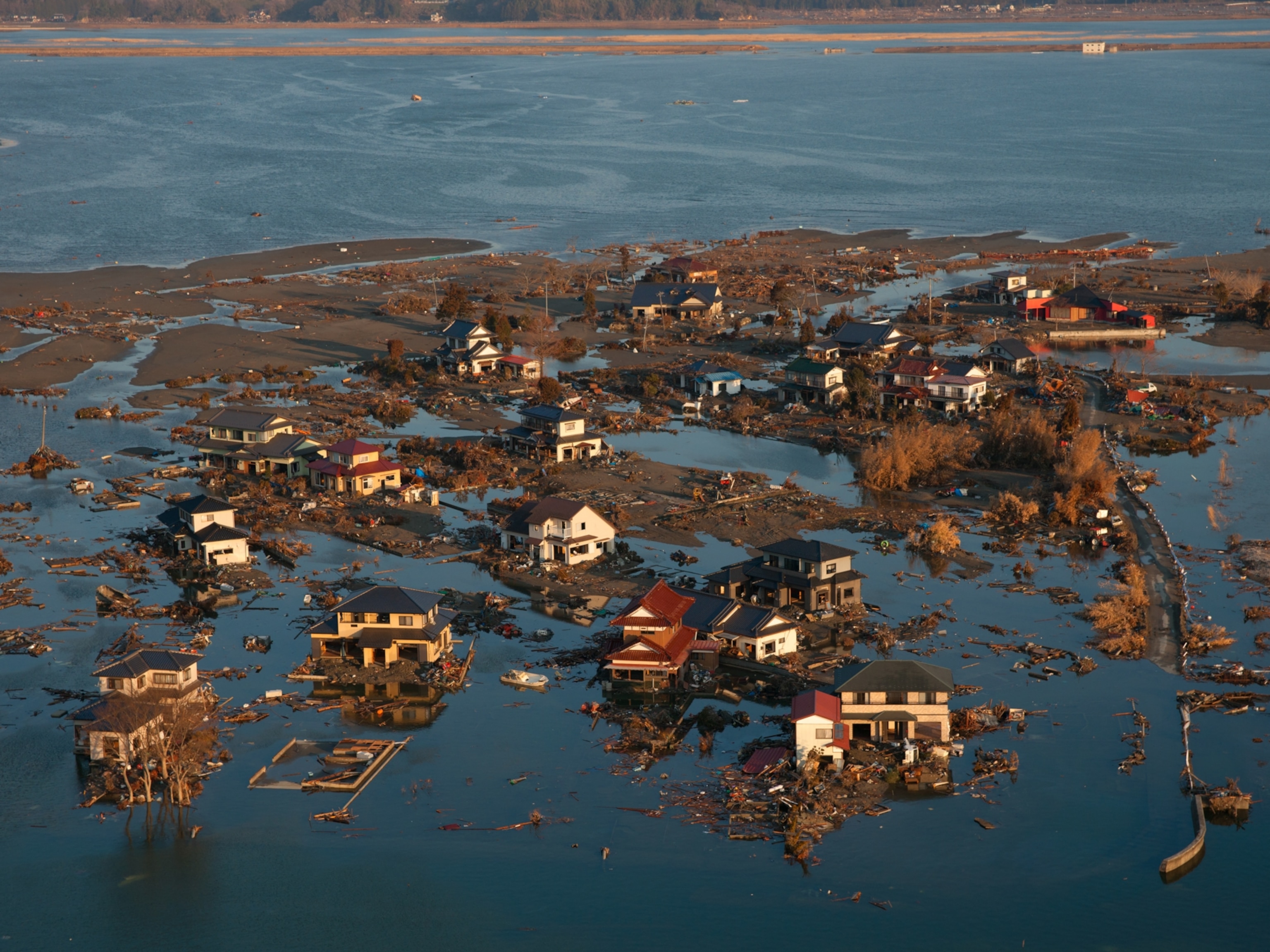
Japan, 2011.
On March 11, 2011, a magnitude 9 earthquake 80 miles off the northeast coast of Japan triggered a series of tsunamis that struck nearby shorelines and the Fukushima Daiichi nuclear power plant.
Tsunami Information
Tsunami & earthquake research, pacific tsunami warning center, lessons from the 2004 indian ocean tsunami.
October 31, 2006 To establish a stronger link between the ocean research and engineering leadership of Woods Hole Oceanographic Institution (WHOI) and major national and international hazard mitigation programs, WHOI organized a colloquium on natural disaster management with a focus on the 2004 Indian Ocean tsunami.
Natural Disasters Related Topics
Tsunamis: Facts About Killer Waves
Get the basics on tsunamis: what they are, what causes them, how they can be avoided, and more.
The Indian Ocean tsunami generated by the most powerful earthquake in decades on December 26 is believed to have killed more than 150,000 people and made millions homeless, making it perhaps the most destructive tsunami in history.
The epicenter of the 9.0 magnitude quake was under the Indian Ocean near the west coast of the Indonesian island of Sumatra, according to the U.S. Geological Survey, which monitors earthquakes worldwide. A violent movement of the Earth's tectonic plates displaced an enormous amount of water, sending powerful shock waves in every direction.
Within hours killer waves radiating from the epicenter slammed into the coastline of 11 Indian Ocean countries, snatching people out to sea, drowning others in their homes or on beaches, and demolishing property from Africa to Thailand.
Tsunamis have been relatively rare in the Indian Ocean. They are most prevalent in the Pacific. But every ocean has generated the scourges. Many countries are at risk.
In the wake of the Christmas weekend tsunami in the Indian Ocean, one of the worst disasters in history, National Geographic News examines the killer waves' causes and warning signs—information that can be a lifesaver in a tsunami zone.
• A tsunami is a series of great sea waves caused by an underwater earthquake, landslide, or volcanic eruption. More rarely, a tsunami can be generated by a giant meteor impact with the ocean.
FREE BONUS ISSUE
Scientists have found traces of an asteroid-collision event that they say would have created a giant tsunami that swept around the Earth several times, inundating everything except the mountains 3.5 billion years ago. The coastline of the continents was changed drastically and almost all life on land was exterminated. ( Read the story )
• Tsunami (pronounced soo-NAH-mee) is a Japanese word. Tsunamis are fairly common in Japan and many thousands of Japanese have been killed by them in recent centuries.
• An earthquake generates a tsunami if it is of sufficient force and there is violent movement of the earth causing substantial and sudden displacement of a massive amount of water.
• A tsunami is not a single wave but a series of waves, also known as a wave train. The first wave in a tsunami is not necessarily the most destructive. Tsunamis are not tidal waves.
• Tsunami waves can be very long (as much as 60 miles, or 100 kilometers) and be as far as one hour apart. They are able to cross entire oceans without great loss of energy. The Indian Ocean tsunami traveled as much as 3,000 miles (nearly 5,000 kilometers) to Africa, arriving with sufficient force to kill people and destroy property.
Scientists say that a great earthquake of magnitude 9 struck the Pacific Northwest in 1700, and created a tsunami that caused flooding and damage on the Pacific coast of Japan. ( Read the story )
As Fast as a Commercial Jet
• When the ocean is deep tsunamis can travel unnoticed on the surface at speeds up to 500 miles per hour (800 kilometers per hour), crossing the entire ocean in a day or less. Scientists are able to calculate arrival times of tsunamis in different parts of the world based on their knowledge of when the event that generated them occurred, water depths, and distances.
• A tsunami may be less than a foot (30 centimeters) in height on the surface of the open ocean, which is why they are not noticed by sailors. But the powerful shock wave of energy travels rapidly through the ocean as fast as a commercial jet. Once a tsunami reaches shallow water near the coast it is slowed down. The top of the wave moves faster than the bottom, causing the sea to rise dramatically.
• Geological features such as reefs, bays, river entrances, and undersea formations may dissipate the energy of a tsunami. In some places a tsunami may cause the sea to rise vertically only a few inches or feet. In other places tsunamis have been known to surge vertically as high as 100 feet (30 meters). Most tsunamis cause the sea to rise no more than 10 feet (3 meters).
The Indian Ocean tsunami caused waves as high as 30 feet (9 meters) in some places, according to news reports. In other places witnesses described a rapid surging of the ocean.
Flooding can extend inland by a thousand feet (300 meters) or more. The enormous energy of a tsunami can lift giant boulders, flip vehicles, and demolish houses. Knowledge of the history of tsunamis in your area is a good indicator of what is likely to happen in a future tsunami event.
• Tsunamis do not necessarily make their final approach to land as a series of giant breaking waves. They may be more like a very rapidly rising tide. This may be accompanied by much underwater turbulence, sucking people under and tossing heavy objects around. Entire beaches have been stripped away by tsunamis.
You May Also Like

3,600-year-old tsunami ‘time capsule’ sheds light on one of humanity’s greatest disasters

A tsunami could wipe this Norwegian town off the map. Why isn’t everyone leaving?

Source of mysterious global tsunami found near Antarctica
Many people have said a tsunami sounds like a freight train.
• The 2004 Indian Ocean tsunami could rank as the most devastating on record. News reports so far suggest that more than 150,000 people may have lost their lives, many of them washed out to sea.
The most damaging tsunami on record before 2004 was the one that killed an estimated 40,000 people in 1782 following an earthquake in the South China Sea. In 1883 some 36,500 people were killed by tsunamis in the South Java Sea, following the eruption of Indonesia's Krakatoa volcano. In northern Chile more than 25,000 people were killed by a tsunami in 1868.
• The Pacific is by far the most active tsunami zone, according to the U.S. National Oceanic and Atmospheric Administration (NOAA). But tsunamis have been generated in other bodies of water, including the Caribbean and Mediterranean Seas, and the Indian and Atlantic Oceans. North Atlantic tsunamis included the tsunami associated with the 1775 Lisbon earthquake that killed as many as 60,000 people in Portugal, Spain, and North Africa. This quake caused a tsunami as high as 23 feet (7 meters) in the Caribbean.
• The Caribbean has been hit by 37 verified tsunamis since 1498. Some were generated locally and others were the result of events far away, such as the earthquake near Portugal. The combined death toll from these Caribbean tsunamis is about 9,500.
• Large tsunami waves were generated in the Marmara Sea in Turkey after the Izmit earthquake of 1999.
Warning Signs
• An earthquake is a natural tsunami warning. If you feel a strong quake do not stay in a place where you are exposed to a tsunami. If you hear of an earthquake be aware of the possibility of a tsunami and listen to the radio or television for additional information. Remember that an earthquake can trigger killer waves thousands of miles across the ocean many hours after the event generated a tsunami.
• Witnesses have reported that an approaching tsunami is sometimes preceded by a noticeable fall or rise in the water level. If you see the ocean receding unusually rapidly or far it's a good sign that a big wave is on its way. Go to high ground immediately.
Many people were killed by the Indian Ocean tsunami because they went down to the beach to view the retreating ocean exposing the seafloor. Apparently they were unaware that this phenomenon precedes a killer wave. Experts believe that a receding ocean may give people as much as five minutes' warning to evacuate the area.
• Because tsunamis can approach the shore as fast as 100 miles per hour (160 kilometers per hour) it is often too late to get away if you see one. An approaching tsunami is not something to be admired unless you are safely on high ground.
• Remember that a tsunami is a series of waves and that the first wave may not be the most dangerous. The danger from a tsunami can last for several hours after the arrival of the first wave. A tsunami wave train may come as a series of surges that are five minutes to an hour apart. The cycle may be marked by a repeated retreat and advance of the ocean. Stay out of danger until you hear it is safe.
Survivors of the Indian Ocean tsunami reported that the sea surged out as fast and as powerfully as it came ashore. Many people were seen being swept out to sea when the ocean retreated.
• A tsunami surge may be small at one point of the shore and large at another point a short distance away. Do not assume that because there is minimal sign of a tsunami in one place it will be like that everywhere else.
• Tsunamis can travel up rivers and streams that lead to the ocean. Stay away from rivers and streams that lead to the ocean as you would stay away from the beach and ocean if there is a tsunami.
• It's always a good idea to keep a store of emergency supplies that include sufficient medications, water, and other essentials sufficient for at least 72 hours. Tsunami, earthquake, hurricane—an emergency can develop with little or no warning.
Advice for Sailors
• NOAA advises that since tsunami wave activity is imperceptible in the open ocean, vessels should not return to port if they are at sea and a tsunami warning has been issued for the area. Tsunamis can cause rapid changes in water level and unpredictable, dangerous currents in harbors and ports. Boat owners may want to take their vessels out to sea if there is time and they are allowed to do so by port authorities. People should not stay on their boats moored in harbors. Tsunamis often destroy boats and leave them wrecked above the normal waterline.
• Heightened awareness of the potential for a tsunami to inundate the U.S. western coastline has caused NOAA, the U.S. Geological Survey, and the Federal Emergency Management Administration to initiate a program to predict tsunamis more accurately. As a tsunami traverses the ocean, a network of sensitive recorders on the sea floor measures pressure changes in the overhead water, sending the information to sensors on buoys, which, in turn, relay the data to satellites for immediate transmission to warning centers.
• The Tsunami Warning System (TWS) in the Pacific, comprised of 26 member countries, monitors seismological and tidal stations throughout the Pacific region. The system evaluates potentially tsunamigenic earthquakes and issues tsunami warnings. There is no international warning system for tsunamis in the Indian Ocean.
• Use your common sense. If you feel or hear of a strong earthquake do not wait for an official tsunami warning. Tell your family and friends to join you in leaving for high ground.
Related Topics

The Tonga eruption explained, from tsunami warnings to sonic booms

The Calm Before the Wave
Japan's 2011 megaquake left a scar at the bottom of the sea. Scientists finally explored it.

Tsunami Quiz: Ten Facts on Killer Waves
What causes earthquakes?
- Perpetual Planet
- Environment
- History & Culture
- Paid Content
History & Culture
- Photography
- Terms of Use
- Privacy Policy
- Your US State Privacy Rights
- Children's Online Privacy Policy
- Interest-Based Ads
- About Nielsen Measurement
- Do Not Sell or Share My Personal Information
- Nat Geo Home
- Attend a Live Event
- Book a Trip
- Inspire Your Kids
- Shop Nat Geo
- Visit the D.C. Museum
- Learn About Our Impact
- Support Our Mission
- Advertise With Us
- Customer Service
- Renew Subscription
- Manage Your Subscription
- Work at Nat Geo
- Sign Up for Our Newsletters
- Contribute to Protect the Planet
Copyright © 1996-2015 National Geographic Society Copyright © 2015-2024 National Geographic Partners, LLC. All rights reserved

.cls-3{fill:#007faa;}.cls-4{fill:none;stroke:#046b99;stroke-miterlimit:10;} dot gov icon Official websites use .gov
A .gov website belongs to an official government organization in the United States.
.cls-1{fill:#549500;}.cls-2{fill:none;stroke:#458600;stroke-miterlimit:10;} https icon Secure websites use HTTPS
A small lock or https:// means you’ve safely connected to a .gov website. Share sensitive information only on official, secure websites.
NOAA Planet Stewards is now accepting proposals for 2023/2024 project funding!
What is a tsunami?
A tsunami is a series of waves caused by earthquakes or undersea volcanic eruptions..

On September 29, 2009, a tsunami caused substantial damage and loss of life in American Samoa, Samoa, and Tonga. The tsunami was generated by a large earthquake in the Southern Pacific Ocean.
Did you know?
Tsunamis are giant waves caused by earthquakes or volcanic eruptions under the sea. Out in the depths of the ocean, tsunami waves do not dramatically increase in height. But as the waves travel inland, they build up to higher and higher heights as the depth of the ocean decreases. The speed of tsunami waves depends on ocean depth rather than the distance from the source of the wave. Tsunami waves may travel as fast as jet planes over deep waters, only slowing down when reaching shallow waters. While tsunamis are often referred to as tidal waves, this name is discouraged by oceanographers because tides have little to do with these giant waves.
More Information
Tsunami "Fast Draw" Animation
Tracking Tsunamis (Ocean Today Video)
National Weather Service TsunamiReady ™
NOAA Deep-ocean Assessment and Reporting of Tsunamis (DART)
NOAA Tsunami Program
Last updated:
Author: NOAA
How to cite this article

An official website of the United States government
Here's how you know
Official websites use .gov A .gov website belongs to an official government organization in the United States.
Secure .gov websites use HTTPS A lock ( ) or https:// means you’ve safely connected to the .gov website. Share sensitive information only on official, secure websites.
- Digg
Latest Earthquakes | Chat Share Social Media
Life of a Tsunami
Panel 1—Initiation

Earthquakes are commonly associated with ground shaking that is a result of elastic waves traveling through the solid earth.
However, near the source of submarine earthquakes, the seafloor is "permanently" uplifted and down-dropped, pushing the entire water column up and down. The potential energy that results from pushing water above mean sea level is then transferred to horizontal propagation of the tsunami wave (kinetic energy). For the case shown above, the earthquake rupture occurred at the base of the continental slope in relatively deep water. Situations can also arise where the earthquake rupture occurs beneath the continental shelf in much shallower water.
Note: In the figure, the waves are greatly exaggerated compared to water depth. In the open ocean, the waves are at most several meters high spread over many tens to hundreds of kilometers in length.
Panel 2—Split

Within several minutes of the earthquake, the initial tsunami (Panel 1) is split into a tsunami that travels out to the deep ocean (distant tsunami) and another tsunami that travels towards the nearby coast (local tsunami). The height above mean sea level of the two oppositely traveling tsunamis is approximately half that of the original tsunami (Panel 1). (This is somewhat modified in three dimensions, but the same idea holds.) The speed at which both tsunamis travel varies as the square root of the water depth. Therefore, the deep-ocean tsunami travels faster than the local tsunami near shore.
Panel 3—Amplification

Several things happen as the local tsunami travels over the continental slope. Most obvious is that the amplitude increases. In addition, the wavelength decreases. This results in steepening of the leading wave--an important control of wave runup at the coast (next panel). Note that the first part of the wave reaching the local shore is a trough, which will appear as the sea receeding far from shore. This is a common natural warning sign for tsunamis. Note also that the deep ocean tsunami has traveled much farther than the local tsunami because of the higher propagation speed. As the deep ocean tsunami approaches a distant shore, amplification and shortening of the wave will occur, just as with the local tsunami shown above.
Panel 4—Runup

Tsunami runup occurs when a peak in the tsunami wave travels from the near-shore region onto shore. Runup is a measurement of the height of the water onshore observed above a reference sea level.
Except for the largest tsunamis, such as the 2004 Indian Ocean event, most tsunamis do not result in giant breaking waves (like normal surf waves at the beach that curl over as they approach shore). Rather, they come in much like very strong and fast-moving tides (i.e., strong surges and rapid changes in sea level). Much of the damage inflicted by tsunamis is caused by strong currents and floating debris. The small number of tsunamis that do break often form vertical walls of turbulent water called bores. Tsunamis will often travel much farther inland than normal waves.
Persistence of Tsunami Waves
Do tsunamis stop once on land? No! After runup, part of the tsunami energy is reflected back to the open ocean and scattered by sharp variations in the coastline. In addition, a tsunami can generate a particular type of coastal trapped wave called an edge wave. Edge waves travel back-and forth, parallel to shore. This results in many arrivals of the tsunami at a particular point on the coast rather than an arrival as a single wave. Because of the complicated behavior of tsunami waves near the coast, the first amplitude and surge (runup) of a tsunami is often not the largest, emphasizing the importance of not returning to a beach many hours after a tsunami initially hits.
Northern California
To illustrate this phenomenon, the simulations below show tsunami wave behavior along the northern California coastline. For visualization purposes, tsunami wave amplitudes are exaggerated and 2.5 hours of elapse time has been compressed into 30 seconds of animation time.
Resonance within harbors and estuaries is not shown in these simulations, but it is another important aspect that contributes to the persistence of tsunami waves.
Note: these animations might take a moment to load, depending on your internet speed. If they do not play immediately upon clicking the play button, please give them some time to load.
Central California
The simulations below show tsunami wave behavior long the central California coastline. For visualization purposes, tsunami wave amplitudes are exaggerated and 70 minutes of elapse time has been compressed into 20 seconds of animation time.
Related Content
Below are our featured “USGS Tsunami and Earthquake Research” pages.

Tsunami and Earthquake Research

Could It Happen Here?
The Question: Soon after the devastating tsunamis in the Indian Ocean on December 26, 2004 and in Japan on March 11, 2011, many people have asked, "Could such a tsunami happen in the United States?"
Local Tsunamis in the Pacific Northwest
In the past century, several damaging tsunamis have struck the Pacific Northwest coast (Northern California, Oregon, and Washington). All of these tsunamis were distant tsunamis generated from earthquakes located far across the Pacific basin and are distinguished from tsunamis generated by earthquakes near the coast—termed local tsunamis.
- Global Assessment Report (GAR)
- PreventionWeb
Special Events
- Global Platform
- International Day for Disaster Reduction
- World Tsunami Awareness Day
- Sendai Framework Monitor
- Voluntary Commitments
Please help us improve PreventionWeb by taking this brief survey. Your input will allow us to better serve the needs of the DRR community.
See the survey
What causes a tsunami? An ocean scientist explains the physics of these destructive waves

On Jan. 15, 2022, the Hunga Tonga-Hunga Ha’apai volcano in Tonga erupted, sending a tsunami racing across the Pacific Ocean in all directions.
As word of the eruption spread, government agencies on surrounding islands and in places as far away as New Zealand, Japan and even the U.S. West Coast issued tsunami warnings. Only about 12 hours after the initial eruption, tsunami waves a few feet tall hit California shorelines – more than 5,000 miles away from the eruption.
I’m a physical oceanographer who studies waves and turbulent mixing in the ocean. Tsunamis are one of my favorite topics to teach my students because the physics of how they move through oceans is so simple and elegant.
Waves that are a few feet tall hitting a beach in California might not sound like the destructive waves the term calls to mind, nor what you see in footage of tragic tsunamis from the past . But tsunamis are not normal waves, no matter the size. So how are tsunamis different from other ocean waves? What generates them? How do they travel so fast? And why are they so destructive?
Deep displacement
Most waves are generated by wind as it blows over the ocean’s surface, transferring energy to and displacing the water. This process creates the waves you see at the beach every day.
Tsunamis are created by an entirely different mechanism. When an underwater earthquake, volcanic eruption or landslide displaces a large amount of water, that energy has to go somewhere – so it generates a series of waves. Unlike wind-driven waves where the energy is confined to the upper layer of the ocean, the energy in a series of tsunami waves extends throughout the entire depth of the ocean. Additionally, a lot more water is displaced than in a wind-driven wave.
Imagine the difference in the waves that are created if you were to blow on the surface of a swimming pool compared to the waves that are created when someone jumps in with a big cannonball dive. The cannonball dive displaces a lot more water than blowing on the surface, so it creates a much bigger set of waves.
Earthquakes can easily move huge amounts of water and cause dangerous tsunamis. Same with large undersea landslides. In the case of the Tonga tsunami, the massive explosion of the volcano displaced the water. Some scientists are speculating that the eruption also caused an undersea landslide that contributed to the large amount of displaced water. Future research will help confirm whether this is true or not.
This simulation from the National Oceanic and Atmospheric Administration shows how tsunami waves propagated away from an earthquake that occurred about 600 miles from Tonga in 2021.
Tsunami waves travel fast
No matter the cause of a tsunami, after the water is displaced, waves propagate outward in all directions – similarly to when a stone is thrown into a serene pond.
Because the energy in tsunami waves reaches all the way to the bottom of the ocean, the depth of the sea floor is the primary factor that determines how fast they move. Calculating the speed of a tsunami is actually quite simple. You just multiply the depth of the ocean – 13,000 feet (4,000 meters) on average – by gravity and take the square root. Doing this, you get an average speed of about 440 miles per hour (700 kilometers per hour). This is much faster than the speed of typical waves, which can range from about 10 to 30 mph (15 to 50 kph).
This equation is what oceanographers use to estimate when a tsunami will reach faraway shores. The tsunami on Jan. 15 hit Santa Cruz, California, 12 hours and 12 minutes after the initial eruption in Tonga. Santa Cruz is 5,280 miles (8,528 kilometers) from Tonga, which means that the tsunami traveled at 433 mph (697 kph) – nearly identical to the speed estimate calculated using the ocean’s average depth.
Destruction on land
Tsunamis are rare compared to ubiquitous wind-driven waves, but they are often much more destructive. The 2004 Indian Ocean tsunami killed 225,000 people. More than 20,000 lost their lives in the 2011 Japan tsunami.
What makes tsunamis so much more destructive than normal waves?
In the open ocean, tsunami waves can be small and may even be undetectable by a boat at the surface. But as the tsunami approaches land, the ocean gets progressively shallower and all the wave energy that extended thousands of feet to the bottom of the deep ocean gets compressed. The displaced water needs to go somewhere. The only place to go is up, so the waves get taller and taller as they approach shore.
When tsunamis get to shore, they often do not crest and break like a typical ocean wave. Instead, they are more like a large wall of water that can inundate land near the coast. It is as if sea level were to suddenly rise by a few feet or more. This can cause flooding and very strong currents that can easily sweep people, cars and buildings away.
[Get fascinating science, health and technology news. Sign up for The Conversation’s weekly science newsletter .]
Luckily, tsunamis are rare and not nearly as much of a surprise as they once were. There is now an extensive array of bottom pressure sensors, called DART buoys , that can sense a tsunami wave and allow government agencies to send warnings prior to the arrival of the tsunami.
If you live near a coast – especially on the Pacific Ocean where the vast majority of tsunamis occur – be sure to know your tsunami escape route for getting to higher ground, and listen to tsunami warnings if you receive one.
The eruption of the Hunga Tonga-Hunga Ha’apai volcano severed the main communication cable that connects the people of Tonga to the rest of the world. While the science of tsunamis can be fascinating, these are serious natural disasters. Only a few deaths have been reported so far from Tonga, but many people are missing and the true extent of the damage from the tsunami is still unknown.
CC BY-ND 4.0
Editors' recommendations
- About tsunami and the role of warning systems
- World Tsunami Awareness Day; why it matters
- Earthquake depth impacts potential tsunami threat
- These 5 countries have advanced tsunami warning systems
Explore further
Please note: Content is displayed as last posted by a PreventionWeb community member or editor. The views expressed therein are not necessarily those of UNDRR, PreventionWeb, or its sponsors. See our terms of use
Is this page useful?
Thank you. If you have 2 minutes, we would benefit from additional feedback (link opens in a new window) .
Tsunamis 101
Find out how a tsunami is born ... and how it destroys.
Earth Science, Geology, Oceanography, Physics
Loading ...
In Japanese, tsunami means "harbor wave." Tsunamis are ocean waves triggered by an earthquake , volcano, or other movement of the ocean floor. Potentially imperceptible in deep water, a tsunami increases in height as it encounters the shallow waters of shore, often leading to extensive wreckage and loss.
Articles & Profiles
Media credits.
The audio, illustrations, photos, and videos are credited beneath the media asset, except for promotional images, which generally link to another page that contains the media credit. The Rights Holder for media is the person or group credited.
Last Updated
October 19, 2023
User Permissions
For information on user permissions, please read our Terms of Service. If you have questions about how to cite anything on our website in your project or classroom presentation, please contact your teacher. They will best know the preferred format. When you reach out to them, you will need the page title, URL, and the date you accessed the resource.
If a media asset is downloadable, a download button appears in the corner of the media viewer. If no button appears, you cannot download or save the media.
Text on this page is printable and can be used according to our Terms of Service .
Interactives
Any interactives on this page can only be played while you are visiting our website. You cannot download interactives.
Related Resources
Learn about our planet!
How fast does a tsunami travel?
In the deep ocean, a tsunami is about as fast as a jet airplane, traveling around 500 miles per hour. In the very deepest parts of the oceans, the speed can be over 700 miles per hour.
Another popular question is “How fast do tsunamis travel on average?”.
This is what I ran into. tsunamis travel approximately 475 mph in 15,000 feet of water. In 100 feet of water the velocity drops to about 40 mph. Did you know…A tsunami travels from the central Aleutian Islands to Hawaii in about 5 hours and to California in about 6 hours, or from the Portugal coast to North Carolina in about 8.5 hours.
How long does it take for a tsunami to travel?
Tsunami waves can travel up to 800 km/hr (the speed of jets!) in deep waters and become slower at shallow depths. If you lived in Chile and an earthquake produces a tsunami just offshore, then the tsunami could reach the coast of Chile in just 15 to 30 minutes.
What is the fastest a tsunami can go?
If you are at the beach, immediately move inland or to higher ground. If your boat is in deep water and offshore, maintain your position. If your boat is berthed or in shallow water, secure your vessel and move inland or to higher ground. If you are on the coast and cannot move inland, seek shelter in the upper levels of a stable building., and more items.
With wave speeds that can reach as much as 435 miles per hour, a tsunami can travel as far inland as 10 miles, depending on the slope and the shape of the shoreline that it is traveling across. Ships traveling in the deep ocean may pass over a tsunami and not even notice it because a tsunami can cause the waves to be as little as 2 feet high where the water is very deep.
How long does it take for a tsunami to form?
It really depends on where the earthquake or event to trigger the tsunami has occurred and where it is heading as Daniel pointed out. Anywhere from 10s of minutes if near the coast of a continent and up to 24 hours.
How do you calculate the speed of a tsunami?
Tsunami speed can be computed by taking the square root of the product of the acceleration of gravity, which is 32.2 feet (9.8 meters) per second squared, and water depth. In 15,000 feet (4,600 meters) of water, this works out to almost 475 mph (765 km/h).
Scientists are able to calculate arrival times of tsunamis in different parts of the world based on their knowledge of water depths, distances, and when the event that generated them occurred. A tsunami may be less than a foot (30 centimeters) in height on the surface of the open ocean, which is why they are not noticed by sailors.
How do tsunamis happen?
Unauthorized use is prohibited. National Geographic News looks at how the killer waves are caused, what the warning signs are, and how to respond when a tsunami threatens. A tsunami is a series of great sea waves caused by an underwater earthquake, landslide, or volcanic eruption.
This of course begs the inquiry “What is a tsunami?”
A tsunami is a series of extremely long waves caused by a large and sudden displacement of the ocean, usually the result of an earthquake below or near the ocean floor. This force creates waves that radiate outward in all directions away from their source, sometimes crossing entire ocean basins.
Related Posts
What tsunami means.
Tsunamis with runups over one meter (3.28 feet) are particularly dangerous to people and property. Yet, smaller tsunamis can also be dangerous. Strong currents can…
Why did tsunami not affect the animals much?
Tsunami waves which killed over 150,000 people in Indonesia, Malaysia, Sri Lanka, India and Thailand also had a devastating effect on many wild and domestic…
What impact do tsunamis on the environment?
There is very little warning before Tsunamis hit. This means that people living in towns and villages on the coast do not have time to…
Does a tsunami happen after an earthquake?
A tsunami may be expected within minutes after a significant earthquake if people are on the beach or in low coastal areas. Many hours after…
- Newsletters
What causes a tsunami?

The Conversation
The Conversation is an independent, not-for-profit media outlet that uses content sourced from the academic and research community.
On 15 January 2022, the Hunga Tonga-Hunga Ha’apai volcano in Tonga erupted , sending a tsunami racing across the Pacific Ocean in all directions.
As word of the eruption spread, government agencies on surrounding islands and in places as far away as New Zealand, Japan and even the U.S. West Coast issued tsunami warnings. Only about 12 hours after the initial eruption, tsunami waves a few feet tall hit California shorelines – more than 5,000 miles away from the eruption.
I’m a physical oceanographer who studies waves and turbulent mixing in the ocean. Tsunamis are one of my favourite topics to teach my students because the physics of how they move through oceans is so simple and elegant.
Waves that are a few feet tall hitting a beach in California might not sound like the destructive waves the term calls to mind, nor what you see in footage of tragic tsunamis from the past . But tsunamis are not normal waves, no matter the size. So how are tsunamis different from other ocean waves? What generates them? How do they travel so fast? And why are they so destructive?
Deep displacement
Most waves are generated by wind as it blows over the ocean’s surface, transferring energy to and displacing the water. This process creates the waves you see at the beach every day.
Tsunamis are created by an entirely different mechanism. When an underwater earthquake, volcanic eruption or landslide displaces a large amount of water, that energy has to go somewhere – so it generates a series of waves. Unlike wind-driven waves where the energy is confined to the upper layer of the ocean, the energy in a series of tsunami waves extends throughout the entire depth of the ocean. Additionally, a lot more water is displaced than in a wind-driven wave.
Imagine the difference in the waves that are created if you were to blow on the surface of a swimming pool compared to the waves that are created when someone jumps in with a big cannonball dive. The cannonball dive displaces a lot more water than blowing on the surface, so it creates a much bigger set of waves.
Earthquakes can easily move huge amounts of water and cause dangerous tsunamis. Same with large undersea landslides. In the case of the Tonga tsunami, the massive explosion of the volcano displaced the water. Some scientists are speculating that the eruption also caused an undersea landslide that contributed to the large amount of displaced water. Future research will help confirm whether this is true or not.
Tsunami waves travel fast
No matter the cause of a tsunami, after the water is displaced, waves propagate outward in all directions – similarly to when a stone is thrown into a serene pond.

Because the energy in tsunami waves reaches all the way to the bottom of the ocean, the depth of the seafloor is the primary factor that determines how fast they move. Calculating the speed of a tsunami is actually quite simple. You just multiply the depth of the ocean – 13,000 feet (4,000 meters) on average – by gravity and take the square root. Doing this, you get an average speed of about 440 miles per hour (700 kilometres per hour). This is much faster than the speed of typical waves, which can range from about 10 to 30 mph (15 to 50 kph).
This equation is what oceanographers use to estimate when a tsunami will reach faraway shores. The tsunami on Jan. 15 hit Santa Cruz, California, 12 hours and 12 minutes after the initial eruption in Tonga. Santa Cruz is 5,280 miles (8,528 kilometres) from Tonga, which means that the tsunami travelled at 433 mph (697 kph) – nearly identical to the speed estimate calculated using the ocean’s average depth.

Destruction on land
Tsunamis are rare compared to ubiquitous wind-driven waves, but they are often much more destructive. The 2004 Indian Ocean tsunami killed 225,000 people. More than 20,000 lost their lives in the 2011 Japan tsunami.
What makes tsunamis so much more destructive than normal waves?
In the open ocean, tsunami waves can be small and may even be undetectable by a boat at the surface. But as the tsunami approaches land, the ocean gets progressively shallower and all the wave energy that extended thousands of feet to the bottom of the deep ocean gets compressed. The displaced water needs to go somewhere. The only place to go is up, so the waves get taller and taller as they approach shore.
When tsunamis get to shore, they often do not crest and break like a typical ocean wave. Instead, they are more like a large wall of water that can inundate land near the coast. It is as if sea level were to suddenly rise by a few feet or more. This can cause flooding and very strong currents that can easily sweep people, cars and buildings away.
The Hunga Tonga-Hunga Ha’apai eruption: what comes next?
Luckily, tsunamis are rare and not nearly as much of a surprise as they once were. There is now an extensive array of bottom pressure sensors, called DART buoys , that can sense a tsunami wave and allow government agencies to send warnings prior to the arrival of the tsunami.
If you live near a coast – especially on the Pacific Ocean where the vast majority of tsunamis occur – be sure to know your tsunami escape route for getting to higher ground, and listen to tsunami warnings if you receive one.
The eruption of the Hunga Tonga-Hunga Ha’apai volcano severed the main communication cable that connects the people of Tonga to the rest of the world. While the science of tsunamis can be fascinating, these are serious natural disasters. Only a few deaths have been reported so far from Tonga, but many people are missing and the true extent of the damage from the tsunami is still unknown.
Sally Warner , Assistant Professor of Climate Science, Brandeis University
This article is republished from The Conversation under a Creative Commons license. Read the original article .
Originally published by Cosmos as What causes a tsunami?
Please login to favourite this article.

An official website of the United States government
Official websites use .gov A .gov website belongs to an official government organization in the United States.
- JetStream home
- Layers of the Atmosphere
- Air Pressure
- The Transfer of Heat Energy
- Energy Balance
- Hydrologic Cycle
- Precipitation
- Layers of the Ocean
- Ocean Circulations
- The Sea Breeze
- The Marine Layer
- Rip Current Safety
- Global Atmospheric Circulations
- The Jet Stream
- Climate vs. Weather
- Climate Zones
- How clouds form
- The Core Four
- The Basic Ten
- Cloud Chart
- Color of Clouds
- Parcel Theory
- Stability-Instability
- Radiosondes
- Skew-T Log-P Diagrams
- Skew-T Plots
- Skew-T Examples
- Pressure vs. Elevation
- Longwaves and Shortwaves
- Basic Wave Patterns
- Common Features
- Thickness Charts
- Weather Models
- Surface Weather Plots
- Norwegian Cyclone Model
- Types of Weather Phenomena
- Electromagnetic waves
- The Atmospheric Window
- Weather Satellites
- How radar works
- Volume Coverage Patterns (VCP)
- Radar Images: Reflectivity
- Radar Images: Velocity
- Radar Images: Precipitation
- Inter-Tropical Convergence Zone
- Classification
- NHC Forecasts
- Hazards & Safety
- Damage Potential
- ENSO Pacific Impacts
- ENSO Weather Impacts
- Ingredients for a Thunderstorm
- Life Cycle of a Thunderstorm
- Types of Thunderstorms
- Hazard: Hail
- Hazard: Damaging wind
- Hazard: Tornadoes
- Hazard: Flash Floods
- Staying Ahead of the Storms
- How Lightning is Created
- The Positive and Negative Side of Lightning
- The Sound of Thunder
- Lightning Safety
- Frequently Asked Questions
- Types of Derechos
- Where and When
- Notable Derechos
- Keeping Yourself Safe
- Historical Context
- Causes: Earthquakes
- Causes: Landslides
- Causes: Volcanoes
- Causes: Weather
- Propagation
- Detection, Warning, and Forecasting
- Preparedness and Mitigation: Communities
- Preparedness and Mitigation: Individuals (You!)
- Select NOAA Tsunami Resources
- Weather Forecast Offices
- River Forecast Centers
- Center Weather Service Units
- Regional Offices
- National Centers for Environmental Prediction
- NOAA Weather Radio
- NWS Careers: Educational Requirements
- Weather Glossary
- Weather Acronyms
- Learning Lessons
Tsunami Inundation
- 2004 Tsunami Tsunami Generation
- Plates and Quakes
- Tsunamis vs. Wind Waves
- Cascadia Subduction Zone
- DART Preparedness and Mitigation
- Community Preparedness
- Individual Preparedness (You!)
The amount of time it takes a tsunami to reach a coast depends on the location of the source of the tsunami relative to where it may strike land. Therefore, tsunamis are often referred to as local or distant.
The source of a local tsunami is close to a coast and it may arrive at nearby coasts in less than one hour, sometimes in just minutes.
Local tsunamis, also called local-source tsunamis and near-field tsunamis, pose the greatest threat because tsunamis are most damaging near their source, and there is little time to issue official warnings and evacuate. Additionally, official tsunami warning may not come quickly or at all if the source is not an earthquake or if the warning infrastructure is damaged.
Therefore, you must know how to recognize and respond to natural tsunami warnings .
The source of a distant tsunami is far away from a coast, sometimes on the other side of the ocean. This means there is more time to issue and respond to warnings (usually at least three hours).
For example, a tsunami generated off Russia will reach the Pacific Northwest Coast of the United States in 7-8 hours, and a tsunami generated off Chile will reach Southern California in about 13 hours. However, distant tsunamis can still have significant impacts on coastal communities.
Distant tsunamis are also called distant-source tsunamis, far-field tsunamis, and teletsunamis.
A tsunami can be both a local and a distant tsunami. For example, if an earthquake off the coast of Alaska causes a tsunami that affects both Alaska and Hawaii, it is a local tsunami for Alaska, but a distant tsunami for Hawaii.

Not all tsunamis act the same, and each individual one may affect coasts differently due to local bathymetry and topography.
Reefs, bays, entrances to rivers, undersea features, and the slope of the shore can all influence the size, appearance, and impact of tsunamis when they strike the coast. A small nondestructive tsunami in one place may be very large and violent a few miles away.
A tsunami arrives at a coast as a series of successive crests (highest parts of the wave) and troughs (lowest parts of the wave). It may look like a fast-rising flood or a wall of water and will not look or act like a normal wind wave. Tsunamis rarely become great towering breaking waves.
Sometimes a tsunami arrives trough first, and, before the water rushes on land, it suddenly recedes, showing the ocean floor, reefs, and fish like a very low tide.

Tsunamis can travel up rivers and streams that lead to the ocean and wrap around headlands, islands, and sand spits. A tsunami's long wavelength provides more momentum for inundation (flooding), so tsunamis often travel much farther inland than normal waves and are more destructive. A large tsunami can flood low-lying coastal areas more than a mile inland.
The maximum height above sea level a tsunami reaches on shore is called the runup. Most runups are less than 10 feet high, but in extreme cases, can exceed 100 feet when a tsunami strikes near its source.
The first wave to reach the shore may not be the last, the largest, or the most damaging. Large tsunamis may continue for days in some locations, reaching their peak often a couple of hours after arrival and gradually tapering off after that.
The time between tsunami crests is unpredictable and varied, typically ranging from approximately five minutes to two hours. Dangerous tsunami currents can last for days.
IMAGES
VIDEO
COMMENTS
Tsunamis are created by an entirely different mechanism. When an underwater earthquake, volcanic eruption or landslide displaces a large amount of water, that energy has to go somewhere - so it ...
Rushing water from waves, floods, and rivers is incredibly powerful. Just six inches of fast-moving water can knock adults off their feet, and twelve inches can carry away a small car. Tsunamis can be particularly destructive because of their speed and volume. They are also dangerous as they return to the sea, carrying debris and people with them.
A tsunami is not a single wave but a series of waves, also known as a wave train. The first wave in a tsunami is not necessarily the most destructive. Tsunamis are not tidal waves. Tsunami waves ...
Tsunamis race across the sea at up to 500 miles (805 kilometers) an hour—about as fast as a jet airplane. At that pace, they can cross the entire expanse of the Pacific Ocean in less than a day ...
In the deep ocean, tsunamis can move as fast as a jet plane, over 500 mph (800 km/h), and can cross entire oceans in less than a day. The distance between waves is the wavelength. Because of a tsunami's long wavelengths, which can be hundreds of miles, a tsunami is barely noticeable in the deep ocean and rarely more than three feet (one meter ...
Waves travel 500 mph, as fast as an airplane. 500 MPH At 1 ,600 feet deep Wave Height = < 6 ft Waves travel 150 mph, as fast as a train. 150 MPH rv30z0 feet deep ... better understanding of tsunami hazards. How do scientists learn about tsunamis, especially if they happened long ago? Primarily, from eyewitness accounts. ...
Tsunamis are created by an entirely different mechanism. When an underwater earthquake, volcanic eruption or landslide displaces a large amount of water, that energy has to go somewhere - so it ...
Tsunami Science. A tsunami is a series of ocean waves generated by sudden displacements in the sea floor, landslides, or volcanic activity. In the deep ocean, the tsunami wave may only be a few inches high. The tsunami wave may come gently ashore or may increase in height to become a fast moving wall of turbulent water several meters high.
The tsunamis we hear about most often are caused by undersea earthquakes, and the waves they generate can travel at speeds of up to 250 miles per hour and reach tens of meters high when they make landfall and break. They can cause massive flooding and rapid widespread devastation in coastal areas, as happened in Southeast Asia in 2004 and in ...
3.2 How fast does a tsunami travel? The speed of a tsunami depends on the depth of the water it is traveling through. The deeper the water; the faster the tsunami. ... Seismic waves travel about 100 times faster than tsunamis, so information about an earthquake is available before information about any tsunami it may have generated. Three key ...
Tsunamis are created by an entirely different mechanism. When an underwater earthquake, volcanic eruption or landslide displaces a large amount of water, that energy has to go somewhere - so it generates a series of waves. Unlike wind-driven waves where the energy is confined to the upper layer of the ocean, the energy in a series of tsunami ...
In deep water a tsunami can travel as fast as 800 km (500 miles) per hour. The wavelengths are enormous, sometimes exceeding 500 km (about 310 miles), but the wave amplitudes (heights) are very small, only about 30 to 60 cm (1 to 2 feet). The waves' periods (the lengths of time for successive crests or troughs to pass a single point) are very ...
What is a Tsunami? A tsunami is a massive, fast-moving wave created by an underwater earthquake or landslide. The large volume of water displaced by a sudden movement of the seafloor creates a pulse in the ocean that races out from its source at speeds of up to 500 miles per hour and extends thousands of feet below the surface. In deep water, a ...
Shoaling happens because waves experience force from the seabed as the water gets shallower. This slows down the wave - the shallower the water, the slower the wave. In deep water, a tsunami moves very fast and has a long wavelength and a small amplitude. As it enters shallower water, it slows down and the wavelength decreases.
The first wave in a tsunami is not necessarily the most destructive. Tsunamis are not tidal waves. • Tsunami waves can be very long (as much as 60 miles, or 100 kilometers) and be as far as one ...
Tsunamis are giant waves caused by earthquakes or volcanic eruptions under the sea. They speed along as fast as jet planes. As they near land, these waves rear up to great heights and can drown whole islands. Historically tsunamis have been referred to as tidal waves, but that name is discouraged by oceanographers because tides have little effect on tsunamis.
No! After runup, part of the tsunami energy is reflected back to the open ocean and scattered by sharp variations in the coastline. In addition, a tsunami can generate a particular type of coastal trapped wave called an edge wave. Edge waves travel back-and forth, parallel to shore. This results in many arrivals of the tsunami at a particular ...
Tsunami waves travel fast. No matter the cause of a tsunami, after the water is displaced, waves propagate outward in all directions - similarly to when a stone is thrown into a serene pond. Because the energy in tsunami waves reaches all the way to the bottom of the ocean, the depth of the sea floor is the primary factor that determines how ...
Tsunamis are a series of long waves generated by a large and sudden displacement of the ocean. Large earthquakes below or near the ocean floor are the most common cause, but landslides, volcanic activity, certain types of weather, and meteorites can also cause a tsunami. Tsunamis are sometimes referred to as "tidal waves", but this is very ...
Tsunamis 101. Find out how a tsunami is born ... and how it destroys. Failed to fetch. In Japanese, tsunami means "harbor wave." Tsunamis are ocean waves triggered by an earthquake, volcano, or other movement of the ocean floor. Potentially imperceptible in deep water, a tsunami increases in height as it encounters the shallow waters of shore ...
In the deep ocean, a tsunami is about as fast as a jet airplane, traveling around 500 miles per hour. In the very deepest parts of the oceans, the speed can be over 700 miles per hour. Another popular question is "How fast do tsunamis travel on average?". This is what I ran into. tsunamis travel approximately 475 mph in 15,000 feet of water.
Tsunamis are created by an entirely different mechanism. When an underwater earthquake, volcanic eruption or landslide displaces a large amount of water, that energy has to go somewhere - so it ...
Tsunamis can travel up rivers and streams that lead to the ocean and wrap around headlands, islands, and sand spits. A tsunami's long wavelength provides more momentum for inundation (flooding), so tsunamis often travel much farther inland than normal waves and are more destructive. A large tsunami can flood low-lying coastal areas more than a ...