

first tracks | table mountain circumnavigation via ptarmigan ridge ski tour
10 mi . 3800 ft gain . 5400 ft high.
Mount Baker Wilderness
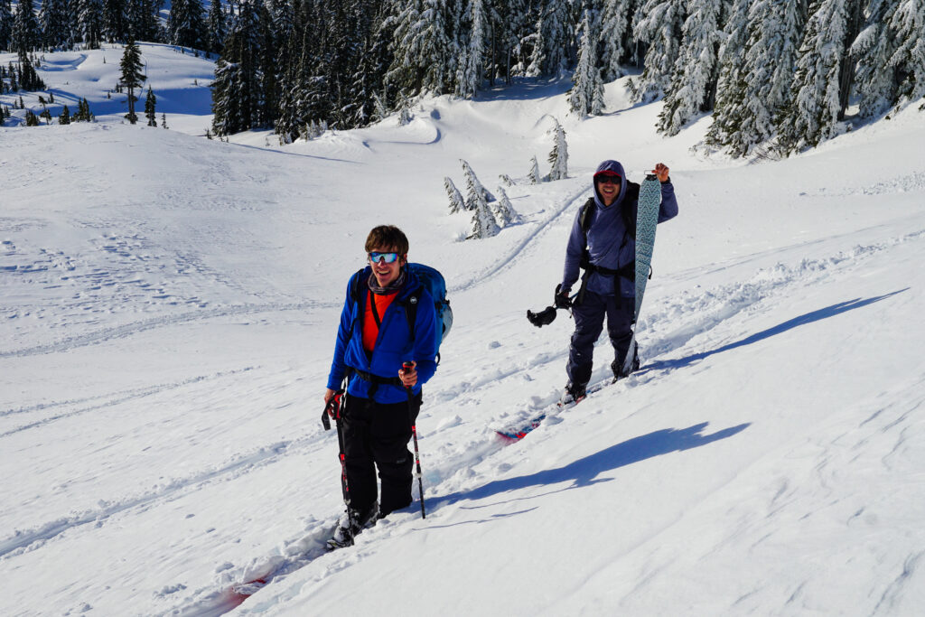
Baker backcountry has been on my list to visit since I first ski toured there right after taking my AIARE 1 class. I think it’s just been a back burner location because the drive is slightly further than most other places and it’s entirely above tree line so avalanche risk tends to be slightly higher, but that also means the skiing is often better! We finally decided to make it happen and we vaguely planned out our route, open to changes and being mindful of the steep sections to either avoid or to push through. Route 542 has always been plowed decently in my experience since there’s a ski resort up there. We parked at the Bagley Lakes Trailhead and oddly enough, for a backcountry lot, there was a parking attendant! He looked a little bored since cars were slow to pull in.

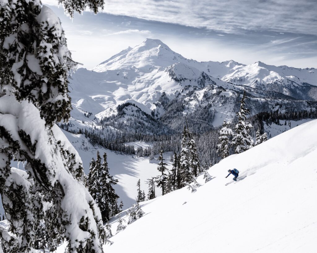
Our main objective was to explore the Ptarmigan ridge. We were all familiar with Table Mountain already and wanted to push beyond. It’s way to easy to fall back to what you know and then fall out of the exploratory phase. For some people, ski touring is a way to get first tracks and powder. For others, it’s simply a way to be outside in nature. And for me, it’s a slight combo of both with a heavy emphasis on finding sweet winter views and exploring somewhere new to me, and obviously a good time with friends!
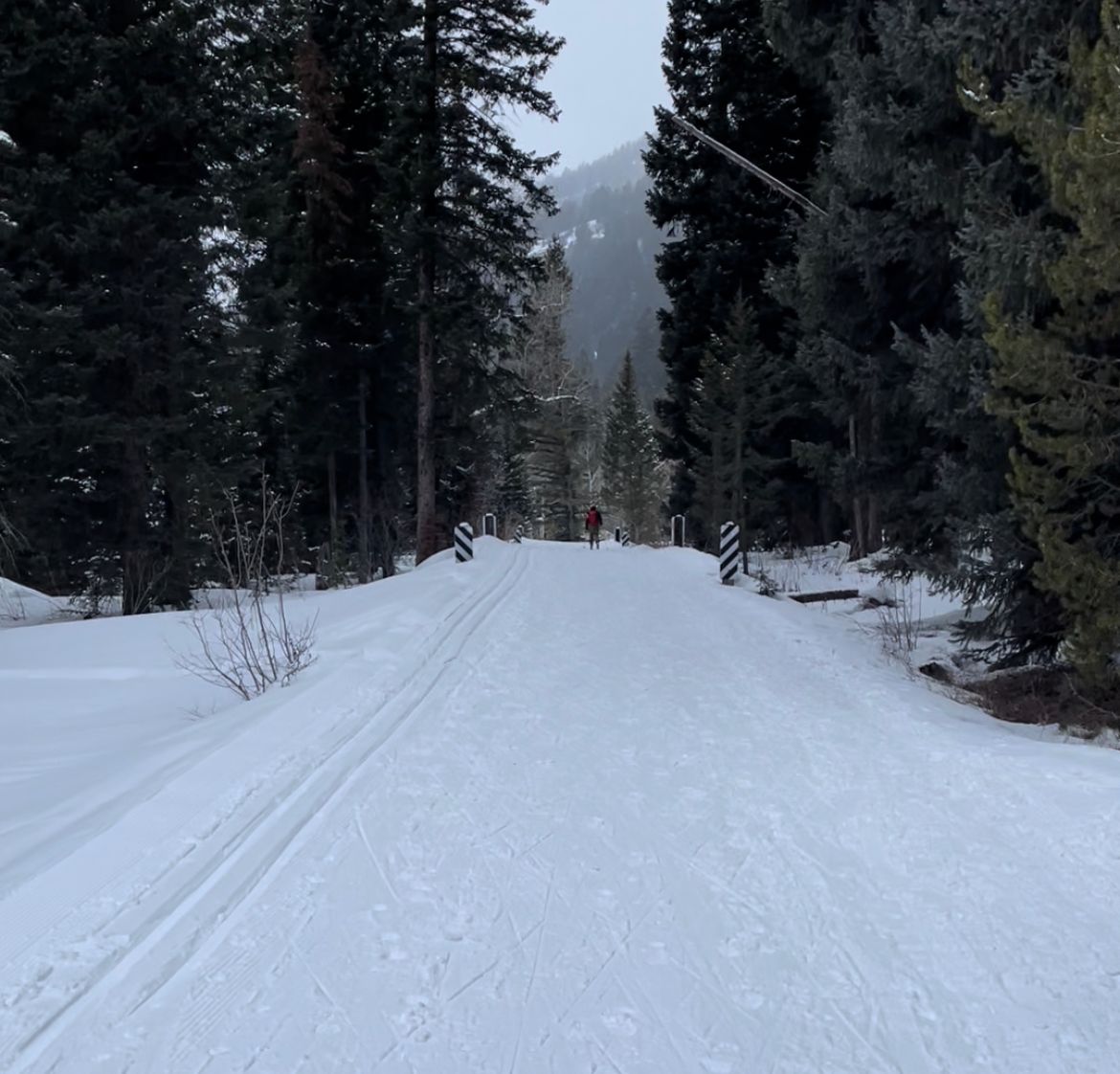
To get to Ptarmigan Ridge, you can either go around the back side of Table Mountain through Artist Point or Bagley Lakes. I honestly have no idea which direction people normally take for the circumnavigation. But we took the Artist Point approach. It was a mostly gentle skin track up to where we found a few tents from snowshoers camping overnight! I hope they got a good sunset or sunrise. The views were so good and the clouds helped keep the peaks from being over-illuminated. We continued further up the shoulder before dropping down a few hundred feet under the south side of Table Mountain. I suppose we could’ve made the run longer instead of a traverse, but the low light conditions with the chunky snow made it incredibly tricky to navigate. It was crusty where your skis would somewhat float but if you fell (like I did), it can be a struggle getting back up and out of the ensnaring snow.

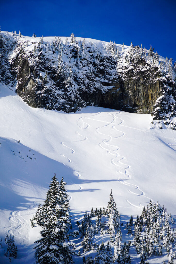
A short ascent later we found ourselves looking straight at the Ptarmigan Ridge with no Mt Baker in sight. All we saw was zero tracks and beautiful layers of fresh snow. I was worried about the snow conditions, and we took our sweet time to transition, like we did every single transition this day. Soon other skiers caught up to us, but we did get first tracks down to the basin! It was still tricky for us and we couldn’t fully connect all our turns. But it was so cool to have the slope to ourselves for such a popular area. Soon the other skiers descended and we all still somehow dispersed to find different slopes afterwards. We stayed low to avoid the large glide crack, but eventually connected back up to the ridge follow another group’s tracks.
We made note of steep bits to avoid and barely were able to determine the smooth route in the low light. The other group went down their path but since the slope is so wide, we still got our own fresh tracks again! This time, it was so buttery smooth and I could fully enjoy it without worrying that my skis would get caught under the crust. We took turns heading down the slope, which was in fairly low avalanche terrain. Once we got down to the flat base, we were wishing for more turns, but with our slower progress, we decided to make a large loop around Table Mountain instead of an out-and-back tour. That way, we could see more!

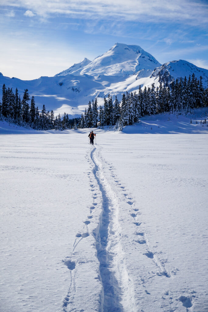
Be careful when crossing some of the streams. There’s some steep chasms that are avoidable if you go around them. Check a map, or keep traversing along the river till you find a good snow bridge. It was easy to use visual cues to see where we were going – Table Mountain was in view the whole time in between the trees! We kept aiming upwards and eventually found a decent old skin track from the day before. Less work is always nice when you know it’s headed the right direction. We crossed over Iceberg Lake and decided to do a short run down the gully. The snow conditions seemed good and we were itching for more skiing, so 400 feet it was!
One final push and we were finally at the top of the ridge above Bagley Lakes. Taking a mellow route down, we ended up a good bit across the basin before we had to put skins back on. The skin route was nice wide highway with few people on it as we padded back up to our car. Surprisingly we stayed on relatively low angle terrain the whole time. I might get pounded for this, but to me, this was still a relatively mellow tour! Long, but gentle slopes!

- Park at the Heather Meadows/Bagley Lakes trailhead where there’s a bathroom that might be heated.
- Overall little trees to navigate, open terrain above tree line, mostly under 25 deg slopes
Photos taken on Canon 5D Mark IV
Share this:
- Click to share on Facebook (Opens in new window)
- Click to share on Pinterest (Opens in new window)
- Click to share on Twitter (Opens in new window)
- Click to print (Opens in new window)
You May Also Like

very-much-whoopy | not-so-sasse peak ski tour

where feet may fail | crater mountain + devils dome loop

multisport fun | rainier attempt via ingraham direct
Leave a reply cancel reply.
Your email address will not be published. Required fields are marked *
Save my name, email, and website in this browser for the next time I comment.
- United States
Table Mountain Ski Tour
Deming, Washington
Elevation Gain
Out-and-Back
Description
Join a supporting community of travelers and adventurers sharing their photos and local insights.
Added by The Outbound Collective
Download the Outbound mobile app
Find adventures and camping on the go, share photos, use GPX tracks, and download maps for offline use.
Table Mountain Ski Tour Reviews
Leave no trace.
Always practice Leave No Trace ethics on your adventures and follow local regulations. Please explore responsibly!

Chain Lakes Loop

Backcountry Skiing Near Mt. Baker

Winter Backpack in the Mt. Baker Backcountry

Winter Backpack to Lake Anne Ridge

Snowshoe to Huntoon Point

Winter Backpack to Artist Point
- Local Adventures
- Tours and trips
- Camping Nearby
- Outbound PRO Membership
- Add your property
Mobile Apps

© 2024 The Outbound Collective - Terms of Use - Privacy Policy
- BLOGLOVIN’
- Search Search
Username or Email Address
Remember Me
Trip Report: Table Mountain Circumnavigation – Mt. Baker Backcountry Skiing
Backcountry skiing around Table Mountain, Herman Saddle & Artist Point
If you’re a skier and you haven’t been to the backcountry around Mt. Baker, you need to go. It’s a playground for backcountry skiers and snowshoers. The views are spectacular, the terrain is endless and the accessibility is easy. We did an overnight snow camping trip at Artist Point and paired that with the Table Mountain circumnavigation ski tour this past weekend.
Trip Details
Ski tour: Table Mountain Circumnavigation (Mt. Baker Ski Area) Distance: 4.6 miles (although, we added more to/from our camp area totaling 6.1 for the day) Time: 5 hours (typical range 4-7 hours) Elevation gain/loss: 1,900 feet (our total elevation was 3,300 for the day with to/from our camp)
If you go skiing at Mt. Baker , check out the Table Mountain route on page 83 of Martin Volken’s Backcountry Ski & Snowboard Routes in Washington for more information.

Artist Point is a popular destination for backcountry skiers and snowshoers . There’s access from the resort (you have to enter through the backcountry gates) that will take you up part of the way. We started from the Upper Heather Meadow parking lot around 9:30 a.m. and commenced the 1.5-mile skin up to Artist Point.
Once at Artist Point, we set up camp, took a lunch break, and discussed our next ski route. The goal for the day was to get some touring distance in, not necessarily get turns in.
The Table Mountain ski traverse is about a 4.6-mile circumnavigation from Artist Point and returns from Herman Saddle.
Starting the traverse from the toe of Table Mountain, we opted to go lower (there were tracks higher up on the toe), which was the right choice. Any higher, we would have been at risk on the steeper pitches on Table Mountain, which are prone to slides and steep .

Once at the other end of Table Mountain, head northwest towards Iceberg Lake. We took our skins off and got a few turns in (pick your terrain here, there are mellow and more challenging options). Once at the lake, we opted for a traverse around to the east side and then crossed over the lake itself.
From here, it’s a pretty burly climb back up to the top of Herman Saddle. Luckily, there were skin tracks switchbacking up skiers right of the gully behind Herman Saddle (there were so many wet loose slides skiers left of the gully, I would not advise traveling on that side).

Herman Saddle is another popular destination for backcountry skiers . The easiest route down is skiing left of the Bagley Lakes basin, which is typically the most popular way back to the Upper Heather Meadow parking area.
We needed to skin back up to our campsite at Artist Point, so opted to go skiers right. Be prepared for variable terrain, there were some steep sections, but also some more mellow pitches skiers left towards the bottom. The snow was less than ideal (crusty from melt-freeze cycles), so skiing was more challenging on the steeper pitches.

Once back at camp, we promptly dug a snow cave for our group and proceeded to have merry times under shelter!
Have you been backcountry skiing around Mt. Baker, Herman Saddle, or the Artist Point area?
For more photos of Artist Point, see our article on AIARE Level 1 Avalanche Training for our field day there.
Updated: December 31, 2020
This post may contain affiliate links to brands we trust. If you use these links to purchase something we may earn a small commission. Thank you for your support!

Kristan Bauer
Kristan is an outdoors gal who loves to spend her time skiing, trail running, and backpacking as much as possible. Kristan has backpacked the John Muir Trail, ice climbed in the North Cascades, and skied throughout North America. Kristan is AIARE 1 avalanche certified and an experienced alpine climber and mountaineer.
Related articles

Guide to Ski Layers For Women
Ski Bibs for Women – Are Bibs For You?

Summer Skiing at Timberline Lodge for Turns All Year

Trip Report: Climbing Mt. Hood – Pearly Gates Route
Leave a reply cancel reply.
Notify me of follow-up comments by email.
Notify me of new posts by email.
Great photos!
Thank you Nancy!
[…] ski tour circumnavigating Table Mountain at Mt. […]
High quality post! I will write about this on my social network.

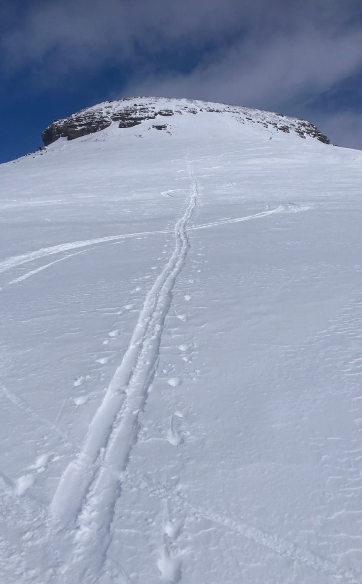
Table Mountain Ski Tour
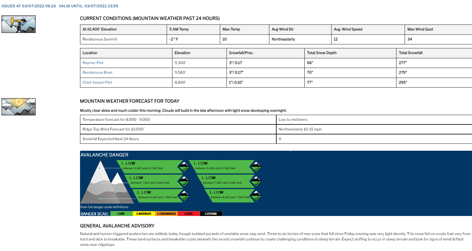
Mon, March 7, 2022 :
- Left New Sheep Bridge Trailhead at 9:30am; returned at 6:30pm.
- 16 miles (including descent) and 4,500’ vertical ascent; 8 miles along Teton Canyon Rd (avoidable with a snowmobile).
- Successful summit; ski descent along our skin track and boot-pack.
Note : I may get commissions for purchases from certain links in this post.
View this post on Instagram A post shared by Alex Rienzie (@alexrienzie)
Table Mountain
Table Mountain is a Wyoming peak on the west side of the Tetons. The summit itself is only a mile west of Grand Teton, offering some of the most rewarding views of any Teton ascent. It's most readily accessible from Driggs, Idaho.
With unparalleled views of Grand, Middle and South Teton, Table Mountain is a very popular summer hike that starts at Teton Canyon trailhead. In the winter, the 4-mile stretch from New Sheep Bridge trailhead to Teton Canyon trailhead is groomed for nordic skiing.
Research and Forecasts
My partner for the trip, Nate, is based on the Idaho side of the Tetons and hiked Table Mountain in prior summers. Winter would be a first, but we had decent beta on the route.
We scouted Table the day before from Grand Targhee, a ski resort just northwest. The best vantage point is the saddle between Mary's Nipple and Peaked Mountain.
Winter 2021-22 was one of the driest on record. Constant high pressure systems in January / February, broken up by a couple 6" storms. We expected snow the day after our tour with flurries on its leading edge – otherwise a clear forecast.
Table Mountain has a few fun chutes and bowls. But as one of our first tours together, we planned to keep it conservative, descending along our skin track and bootpack back to the Teton Canyon Trailhead. With recent high pressure and cold temperatures, avalanche risk was all low. The upper ridgeline ranged from 15-20 degrees. It steepened when we reached dense trees along the bootpack.
We settled on a ~9am departure, enough time to beat the storm with a few spare daylight hours. Earlier would've been better, but I had a COVID test that morning, ahead of a Banff roadtrip in a couple days.
The night before, I packed gear and carbo-loaded. Table Mountain would be one of my first big tours, so I learned a ton and improved gear on subsequent tours. See (comments) and a wish list below.
- Ski gear : Liberty Origin 190s with Salomon frame bindings (my super-heavy starter set-up – bought lighter skis and tech bindings before the Skillet in April); Black Diamond skins and skin savers; Nordica Strider hybrid boots; resort poles (need mid-grips and powder baskets); helmet
- Avalanche gear : Mammut Barryvox beacon , shovel and probe
- Ortovox 26L airbag pack with Voile straps to add outside capacity for skins, shell and helmet (need a larger pack); integrated back protector and whistle
- Ultralight medical kit : bandages, basic medications, antiseptics, tape, etc.; plus extra ibuprofen (knee overuse injury from the prior summer)
- Calories : granola bars and baby food (bad bang-for-weight; next time, more energy gels)
- 1L Nalgene of water with electrolyte powder
- Emergency gear : hand warmers , Leatherman multi-tool , fire starters and Coleman waterproof matches, space blankets and bandana
- Blaze-orange ballcap for visibility (paired with a buff for uphills; fit under helmet on descent)
- GoPro with foam wind cover (helmet mounted)
- Repair kit : Gorilla tape (super duct tape); extra Voile straps (secure ski tips in A-frame carry, gear repairs, etc.)
- Black Diamond LED headlamp
- Extra AAA batteries for headlamp/beacon
- Smith goggles with high-light, low-light and clear lenses; sunglasses for the skin and bootpack
- Layers : Patagonia down sweater; Under Armor base upper ; mid-weight sweater; Helly Hansen shell; North Face insulated ski pants (a bit too warm); Smartwool cushioned ski socks
- Neck gaiter with a fleece bottom (for sun and cold protection)
- Lightweight gloves (ascent), mittens (final ascent) and liners (descent)
My partner also had a Garmin inReach if there was an injury requiring extraction.
Wish list for the next tour :
- Larger repair kit : baling wire, zip ties, hose clamps, etc.
- Extra electrolytes, energy gels (e.g., GU ) and nut butters (e.g., Justin's ) to replace high-water content baby food
- Lightweight touring skis and bindings (one pound on feet = five on back)
- Poles with mid-grips and powder baskets
- Higher-capacity touring backpack
A Flat Skin
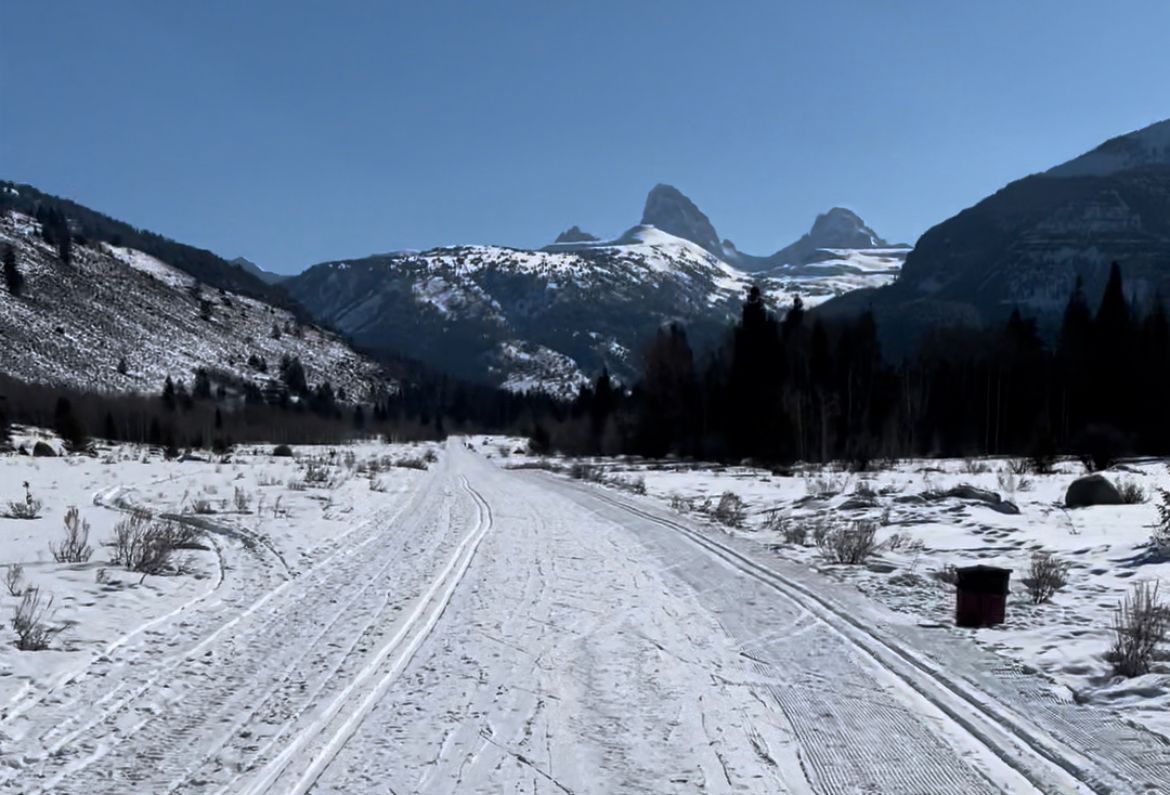
I drove west from a COVID-testing center near the old Kmart (now Target) at 8am. I was driving to Banff in a few days for a ski roadtrip and Canada required a negative test to enter. I planned to meet Nate at the Broulims in Driggs, then drive to the New Sheep Bridge trailhead in Teton Canyon.
The adventure would start with a 4-mile skin on a groomed road to Teton Canyon Trailhead. It was mostly flat with a net 500' elevation gain.
Most skiers snowmobile to the start of their routes in Teton Canyon. Lacking a sled, we opted for the long skin. Mt. Moran's Skillet was on my wish list for that spring. Before Jackson Lake thaws, the Skillet involves a 6-mile skin over the frozen surface. This extra mileage would be a good a trial run. (Check out our trip report from an April 2022 attempt; we fell 1,000' short.)
We talked about going "Nordic" (free heel; no skins), but the route wasn't quite flat enough to make that more efficient.
At 9:30am, we skinned out of Sheep Bridge trailhead, passing nordic skiers and some pups returning from early walks. The road meanders through Teton Canyon and over a couple bridges before reaching the dead-end: Teton Canyon trailhead.
The Idaho-side of the Tetons offers stark contrast. The western edge of the Tetons isn't as steep as its fault line in the east. The range's highest summits – Owen, Grand, Middle and South – are more pronounced, rising above the foothills.
A few snowmobiles zipped past as we skinned. One sled had three skiers in tow, sparking some envy. By 11am, we arrived at Teton Canyon trailhead and transitioned for the bootpack.
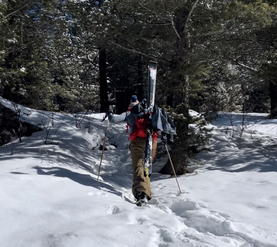
Leaving New Sheep Bridge; bootpack transition at Teton Canyon
Bootpack from Teton Canyon Trailhead
Beacon check, skis in A-frame mode and a quick snack. We followed snowshoe tracks just left of the trailhead restrooms, closed for the season. Our elevation gain would be 4,000' from the trailhead.
We were lucky to find snowshoe tracks that supported our weight. Bootpacking the ridge would be faster than switchbacking on skins. (Occasionally our boots punched through the snow, but not often.)
We trudged up a couple steep sections of pines and aspen groves. The snowshoe tracks followed Table's northwest ridge. There were only a few clouds in the sky. Periodically Nate pointed out surrounding summits. We observed Treasure Mtn. cliff bands to our west dropping beneath us as we climbed.
After ~2,200' and 2 hours, the terrain leveled out. We transitioned to skin the final 1,800' to the summit.
Bootpacking up Table's northwest ridge
Skin (and Bear Crawl) to the Summit
After a quick snack break, we ripped skins and started heading southeast. We'd follow the ridge to the summit, which wasn't yet visible. It was 1pm.
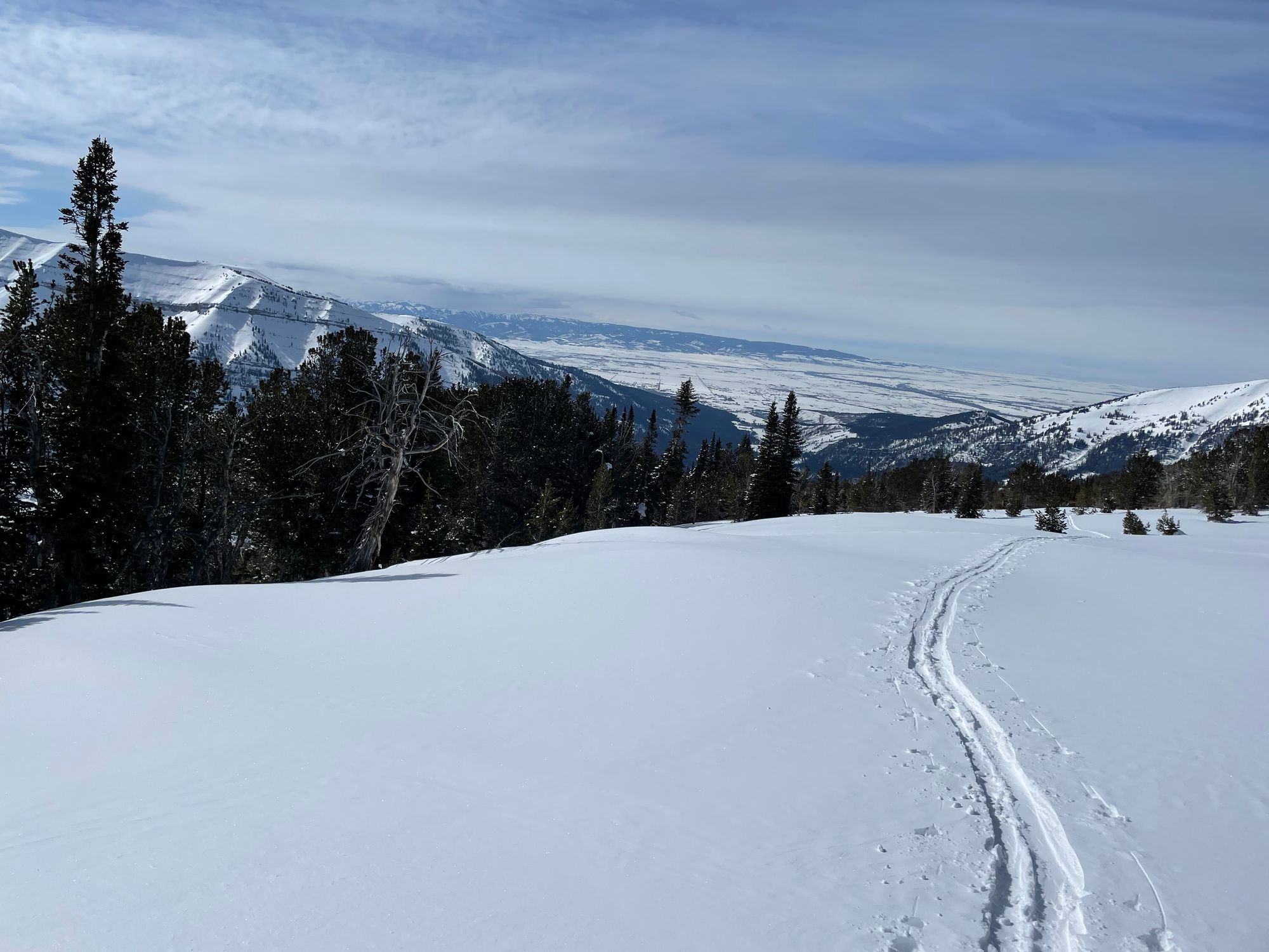
The skin seemed to drag on. I really needed to upgrade my heavy frame bindings. The summit came into view within 30-40 minutes. Most of the ridgeline is 15-20 degrees, lacking trees / boulders to judge distance. My hands were freezing, so I swapped lightweight glovers for mittens.
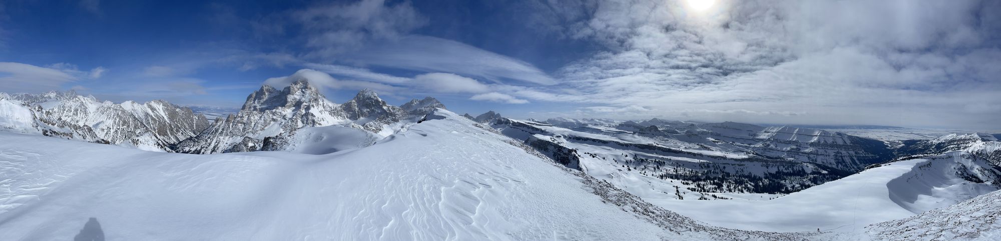
Nate pointed our Battleship Mtn. to our south. It was my first time summiting a mountain in the winter. I soaked up the snowy Teton vistas. The Cathedral Group disappeared behind the Table summit as we approached.
With clouds rolling into Teton Valley to the west and a storm in the overnight forecast, we debated turning around a mile from the summit. A cornice hung to the north of the ridge and there were limited reference points to keep us safe if visibility dropped. (It's safer to ski trees in a white-out.)
The clouds were still aways out, so we kept ascending.
By 2:30pm, an hour and a half into our skin, we neared the summit. The slope steepend to 30 – 40 degrees. I ditched my skis and pack, bear crawling the final 100' with poles in hand. The snow was soft – no crampons / axe needed.
Final approach and summit
Careful to avoid from the leeward edge, I snapped some quick pictures on the summit, then scrambled out of the cold, west wind. (Cornices have a habit of breaking further back than expected.) I slid on my butt through the rock fins below the summit, using my poles to break.
Back to my skis, I transitioned. I felt my hands growing numb – the 30 seconds of exposure for pictures took its toll. I added liners beneath the mittens, swapped my frozen sweater for a puffer and added my shell.
Hands slow, my transition was clumsy. By 3pm skins were packed, frame bindings in downhill mode and helmet buckled.
Ridgeline to our Bootpack
My legs felt like jelly. This was my first long tour. Prior ascents were limited to 1,500-2,000' vertical. I also skied Targhee and deadlifted the day prior – rookie move in retrospect. More calories would've helped.
With a clumsy start, I planned to ski conservatively back to the trailhead.
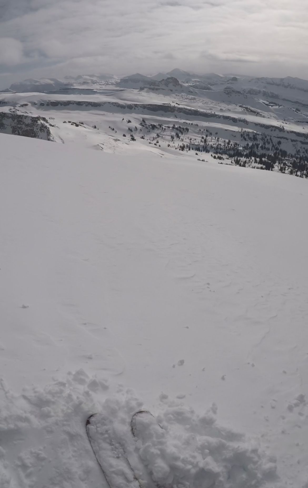
Ridgeline ski descent
We followed our skin track and then bootpack back down the ridge. A few fresh inches of snow from the night before sat on firm snow. For the driest January / February in recent history, I'd take it.
As we descended, snow coverage dropped – less fresh snow and more crusts. When we hit the steeper section with tight trees, we transitioned to bootpack. Our legs were spent and coverage was mediocre.
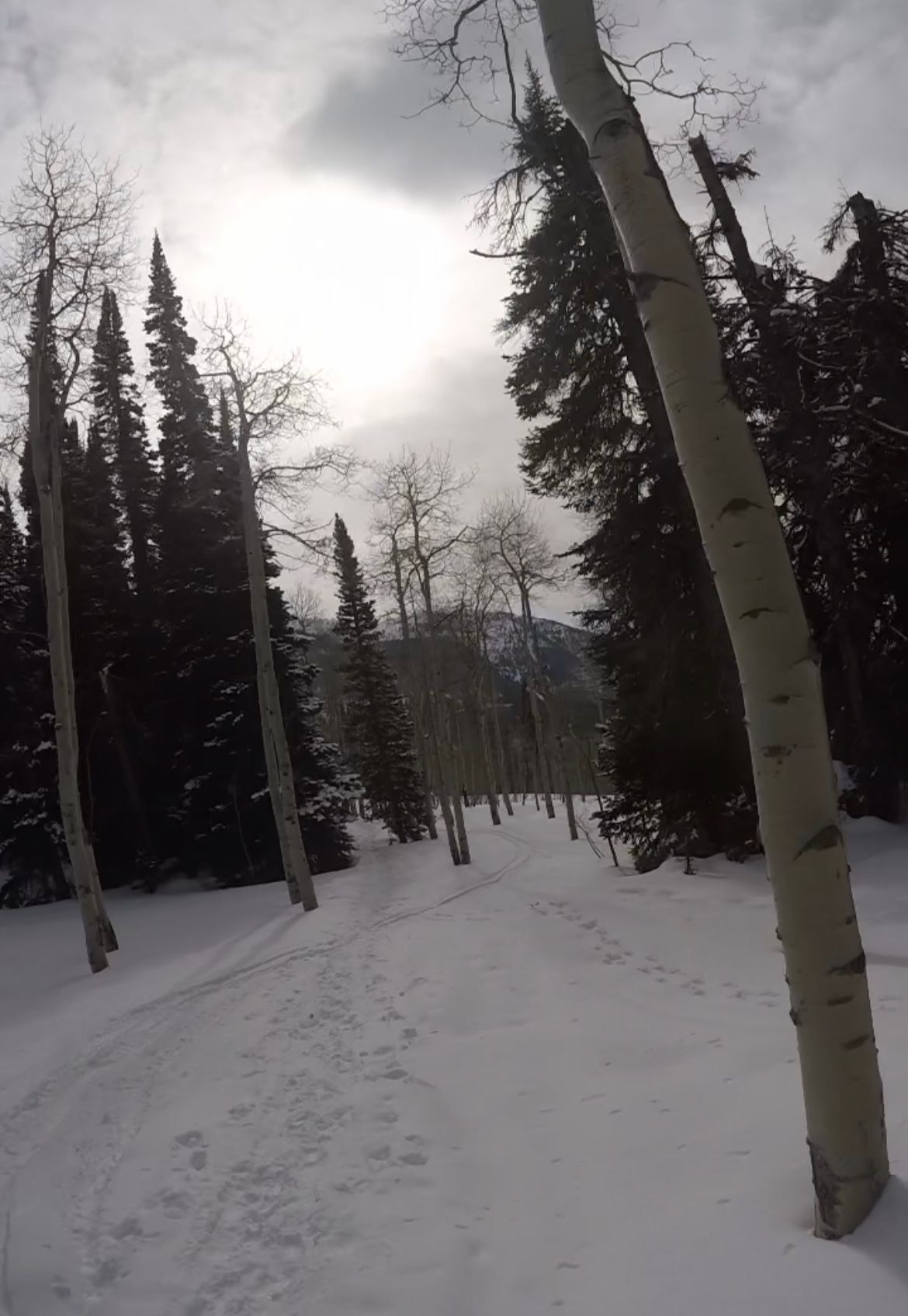
Transition to bootpack
Skis on backs, we hiked down the same snowshoe track we ascended a few hours earlier. Occasionally our boots broke through, which felt riskier facing downhill. I took it slow to minimize injury risk.
At 5pm, we reached the Teton Canyon trailhead, took a quick breather and transitioned for the final skin home.
Final, Flat Skin
That final, flat skin was uneventful, but felt longer than in the morning. We passed one group of hikers halfway back to our cars. Envy of the snowmobile shuttle hit again, but this would be a good trial for the Skillet.
At 6:30pm, we reached our cars. I took a few gulps of water from a jug in my truck and packed up.
Next order of business: Broulim's in Driggs for Pedialyte, a protein bar, baby food and my favorite snack: Spicy Queso Popcorners. Then, an hour drive back to Jackson over Teton Pass.
Snow was picking up, so the drive home was slower than I hoped. Treating myself at home, I whipped up a quick steak with onions / mushrooms and baked potato wedges – a light 9pm dinner.
Final skin and snacks / a light dinner
- More calories, specifically denser options like energy gels and Justin's packs
- More water with electrolytes
- No leg workouts the day before a long tour (duh)
- More carbo-loading / hydration in advance
- Lighter touring equipment
Stats from Apple Watch
- 16 miles, including ski descent, and 4,500' vertical (500' initial skin, 2,200' bootpack and 1,800' final skin / bear crawl)
- 2,500 active calories
Climber Kyle
The only way is up.
- Trip Reports
- Photography
Table Mountain (Almost) Circumnavigation

Balmy Baker Backcountry
A deep freeze arrived in the PNW in early January. The lowlands plummeted into the teens and even single digits – possibly the coldest temperatures I have experienced in my lifetime in Western Washington. With fresh snow and a sunny but bone-chilling forecast, the question was: where should we go to enjoy this ephemeral cold snap during an otherwise warm winter?
Wyatt and I have been producing weekly weather videos for Cascadia Mountain Weather. In our video before this weekend , we focused on the temperatures and wind chills. Due to big pressure gradients, the passes would funnel strong easterly winds, damaging the snow and creating dangerously cold wind chills. So we decided to go north to Baker, seeking more moderate westside temperatures and calm winds. Our decision turned out to be a great one!
The cold weather gave us an excuse for a late start, but we were surprised to find a balmy temperature of 15F at the parking lot – warmer than it was in the lowlands. The wind had just died down and the sun was out! John had driven up from Issaquah with me, and we picked up Wyatt on the way. Our friends Brigette and Anna also joined us for a tour.
The NWAC observations from the day prior spoke of substantial wind effect, especially higher up. So given the cold, our plan was to explore some of the more protected south-facing glades. We figured that a Table Mountain Circumnavigation would be a highly scenic route, and we could assess snow conditions on a variety of aspects along the way.
Skinning through the Bagley Lakes Basin on a sunny morning is like staring at a buffet and wondering what you should eat first. We decided to follow the existing tracks and ski a beautiful east-facing slope beneath Table Mountain in the morning sun. We passed probably 50 people on the way up; it was busy out there!
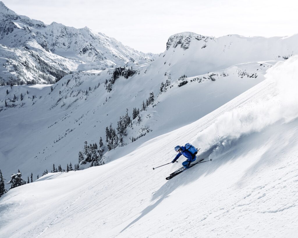
With a little wind effect up top but perfect powder below, it was a great first run! Then we headed back up towards the Herman Saddle to continue on our tour. Without any wind, it was downright balmy in the sun!
We skinned a little higher than Herman Saddle to find some untracked powder on our way down to Iceberg Lake. Despite the warm temps, the snow was completely dry and cold. It is such a rare treat to ski south-facing powder in Western Washington, without any sense of urgency. We knew it was cold enough to stay dry all day.
After seeing probably over a hundred people in the Bagley Lakes Basin, we somehow found ourselves breaking trail across Iceberg Lake as we continued on the circumnavigation.
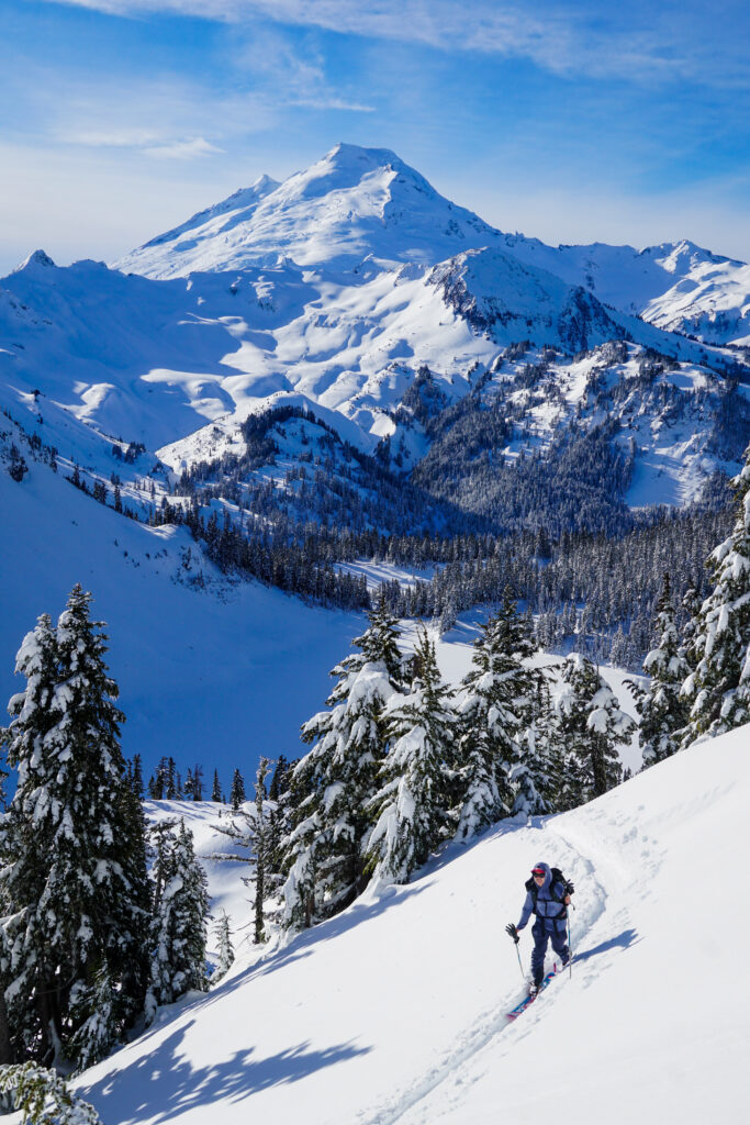
Past Iceberg Lake, we started to run into groups coming the other way on the circumnavigation. I led us up Back Pocket on the south side of Table Mountain. From there, we enjoyed another nice south-facing powder run all the way to the bottom of the Bonsai Trees.
We discussed our options for the rest of the day. We could continue with the standard circumnavigation, but the remainder of the skiing would not be that interesting. Instead, we decided to skin back up Back Pocket again and cross the plateau of Table Mountain to Corner Pocket. This would take us more directly back to the car and give us the option of an additional lap on Herman to finish!
We crossed the top of Table and skied a bumpy but decent run down Corner Pocket. At the bottom, Anna decided to head back to the car while the rest of us quickly transitioned, racing the sun up the south side of Herman. Wyatt’s skin kept failing, so he initially said he would head out with Anna. But a few minutes later I looked down and a single person was following us upwards – Wyatt could not pass on an alpine sunset!
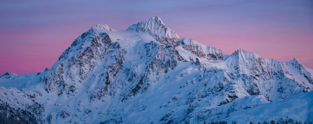
With a steep, icy skintrack, Wyatt’s skin was toast. I set a new, lower angled skin track for a good portion of the way up Herman, allowing Wyatt to limp to the top with a non-adhering skin. It was struggle, but we made it up just in time for an incredible sunset. As we transitioned, we watched Shuksan and the Northern Pickets explode in alpenglow.
Eventually, it was time to ski down, although the light show continued. The glow faded to a deep pink in the sky behind Shuksan. We kept taking photos until it was simply time to get out before dark.
The east face of Herman is rather complex, with plenty of cliffs at the bottom. The main runs were tracked out like a resort. We got lured by untracked powder into a series of cliff bands. Luckily, there were some tracks to follow through some gnarly terrain. It required some careful skiing, but we all made our way through the cliffs and back to the car just before dark!
This was a super fun, surprisingly full-value day in the Baker Backcountry! All we hoped for was reasonable temperatures and calm winds, but we also scored delightful south facing powder and an incredible sunset. Even though nothing was overly adventurous or novel, it was fun to return to this part of the Baker Backcountry after a few years away and use my experience to improvise on the fly. Thank you to Wyatt, John, Brigette, and Anna for a great day!
Leave a Reply Cancel reply
Your email address will not be published. Required fields are marked *
Notify me of follow-up comments by email.
Notify me of new posts by email.
Favorites Today
- Chelan Wineries and Tasting Rooms
- Blaine Webcams & Weather
- Bellingham Webcams & Weather
- Lynden Webcams & Weather
Must see and do in Seattle
Seattle City Pass Savings
Washington State Tours
Providing travel ideas for visitors to washington state.
- Table Mountain With Mt Baker & Mt Shuksan
Hiking Table Mountain with Views of Mount Baker and Mount Shuksan
Table Mountain upper left above Heather Meadows
A drive up the Mount Baker Highway is filled with incredible views all year. In the summer time after the snow has melted visitors flock to Artist Point, the end of the highway and beginning of many scenic walks and hikes. For many visitors Artist Point offers enough views to satisfy them – from their cars on the drive they have seen the Heather Meadows recreation area (perfect picnic stop), the Mount Baker Ski Area , Mt. Shuksan, and Mt. Baker. If you want to sample some hiking with more views but want to take it a little easy the Artist Point Trail will suit your needs perfectly. Remember that you can stay near the mountains too. There are a number of accommodations near Mount Baker as well as places to eat along the Mount Baker Highway.
For those desiring more adventure and more than just a stretch of their legs, the Table Mountain trail offers a perfect solution. Table Mountain is more advanced than the Artist Point Trail – but you will see some spectacular views if you are up to the challenge.
From the top you’ll see both Mt. Baker and Mt. Shuksan, but you’ll also be able to sneak to the edge for horizon stretching views that include Iceberg Lake and the Galena Chain Lakes trail directly below.
While the top of Table Mountain looks easy initially, the route can require light scrambling if there are still snowbanks that haven’t melted. PLEASE USE CAUTION. If you don’t feel comfortable at any point turn back.
You get to Table Mountain by driving up the Mount Baker Highway (Washington State Highway 542) to the Mount Baker Ski Area. Then take a right where you see the large map of Mt. Baker and continue 2.6 miles to the parking lot at Artist Point located on Kulshan Ridge. This is the end of the highway and you are now at 5,100 feet of elevation. This is a National Recreation fee area so make sure you fill out the envelope and deposit your cash ($5 in 2015).
A side note: sometimes the road to Artist Point opens in Late August and sometimes sooner. It all depends on how deep the snow is in the winter and how soon they are able to open the highway to the top.
The trail to Table Mountain begins at the southwest side of the parking lot. You’ll have a choice of intermediate trails but for this adventure you want to take the one on the right. You start to ascend the lava cliffs of Table Mountain right away. At the top you’ll want to sample the view of Shuksan from the southeast edge. Then hike over to the northeast edge. From here you can look down to Iceberg Lake and the valley that contains Bagley Lakes.
About 20 minutes further to the north you will find a large band of rock. Looking down you’ll see a snowfield about 20 to 30 feet below. If you want to attempt the decent, then head to the right to find a stair step of rocks (if these are buried in snow then we don’t recommend the attempt.)
From the top you’ll see a couple of trails below. When you get down to this lower level you’ll follow the right hand fork in the trail for about 10 minutes. You’ll find an sheer edge to the cliffs. Looking down you will see the Galena Chain Lakes trail several hundred feet below. It’s a great view – just don’t go over the edge.
The original Table Mountain loop trail included a snowfield that was considered too dangerous. Now you return on the trail that you took to the top. Old Trail – If you take the left fork you’ll decent to the Galena Chain Lakes trail. This part of the trail will require you to do some scrambling and is no longer marked. From there take a left to the Ptarmigan Ridge trail and make your way back to the parking lot in 1.2 miles.

Tags: slides
No comments yet.
Leave a reply click here to cancel reply..
You must be logged in to post a comment.
NOTE: There are affiliate links on some pages. If you click one of the links and purchase products, we earn a very small commission on your purchase, at no extra cost to you. Thank you for making this blog possible!
- Discount Tickets for Seattle Shows and Events
- 10 Things You Must See and Do in Seattle
- Seattle Webcams & Weather
- 7 Fun “Outside-The-Box” Things For Couples to Do in Seattle
- Video Tour of Seattle Neighborhoods
- Space Needle
- Pike Place Market
- Seattle Underground Tour
- Seattle Central Library
- Seattle Great Wheel
- Wings Over Washington
- Seattle Aquarium
- Experience Music Project
- Seattle CityPASS
- Seattle Hot Air Balloon Ride
- Bellevue Washington
- Seattle Tours
- University Area
- Seattle Area Contacts
- Washington State Ferry
- Bellingham Webcams & Weather
- Blaine Webcams & Weather
- Semiahmoo Webcam Page with Resort and Marina
- Cashmere Washington
- Leavenworth Webcams & Weather
- Leavenworth Restaurant Guide
- Christmas Lighting Festival
- Leavenworth Nutcracker Museum
- Wenatchee Galleries and Studios
- Wenatchee Art on the Avenues
- North Cascades Tours
- Tour The Cascade Loop
- Tacoma Webcams & Weather
- Lewis County
- Volcano Country Tours
- Islands Tours
- A Paradise Called the Palouse
- Washington Wine Country
- Yakima Valley Wine Country
- Recipes From Columbia Cascade Wines And Wineries
- Leavenworth Wineries and Tasting Rooms
- Wenatchee Wineries and Tasting Rooms
- Wine Country Tours
- Wine Glossary and Wine Terms
- Coastal Region Tours
- Kitsap Peninsula
- Peninsula Tours
- Portland Oregon
- Discount Tickets for Portland Shows and Events
- Vancouver B.C. Webcams & Weather
- Where to Stay at Mount Baker
- Where to Eat at Mount Baker
- High-Tech Hiking in Washington: 3 Must-Haves for Your Pack
- Stevens Pass Ski Resort, WA
- Crystal Mountain Ski Resort, WA
- Mount Hood Meadows Ski Resort, OR
- Whistler BC Winter Fun
- Big White Ski Resort, BC
- Tour Companies
- Books / Maps / Gifts
Table Mountain Tour
Table Mountain tour guided service

Instant Confirmation
Pay with Credit or Debit Card
By Clicking “Buy Now” you agree to our Terms and Conditions and Privacy Policy
Table Mountain Tours Are Now Available! ☝ Confirm booking .
4 of the Best Table Mountain Day Tours
Sunrise Tour Best Seller – Table Mountain half-day, early-bird private or group tour from Cape Town at 7:30 AM.

☆☆☆☆☆ Rating: 5 · 20 Reviews. Half-day tour. 3-Hours. Great for early birds!
Fall in love with the beautiful Cape Town upon a half-day, sunrise Table Top sightseeing private or group tour with hotel pickup.
Morning Tour – Daylight dawn sightseeing part-day tour group departing from Cape Town at 10 AM.
☆☆☆☆☆ Rating: 5 · 30 Reviews. Morning half-day. 3-Hour return trip. Great start!
Traverse the Cape Peninsula in a tour group and discover the highest point to view the dramatic coastline, and to take pictures!
Afternoon Tour – Scenic mid-day tour in private transportation from Cape Town at 13:00 PM.
☆☆☆☆ Rating: 4.2 · 15 Reviews. Midday tour. 3-Hours Return Trip. Excellent choice!
Create a personalized mountain adventure tour without the hassle of self-driving. Enjoy door to door pickup from your hotel!
Sunset Tour Best Seller – Sunset special Cable Car Table Mountain group tour or private from Cape Town at 16:00 PM.

☆☆☆☆☆ Rating: 5 · 45 Reviews Evening special. Sundowners 3-Hour Long. Perfect!
See not one, but two oceans on a scenic trip to Cape Town Table Mountain! On-route enjoy the sunset special experience.
Welcome to the vibrant and historical city of Cape Town, South Africa. Life awaits, book a Table Mountain Tour and let’s explore!
Table Mountain Tour company is excited to show you many sights of the Mother City. These range from educational walking tours to Cable Car rides, we’d love to share our expertise with you!
The tours take place within the main city of Cape Town, the highlight of the tour is Table Mountain. We do our best to incorporate visitor interests including the Café, restaurant and Shop on Top. Bird watching enthusiasts will soon find out, there is more animal encounters to meet their expectations, and animals too!
We combine many elements on your travel itinerary to make up the most jam-packed adventure! Try our Table Mountain half-day tour with pickup from any hotel in Cape Town. It will be memorable as possible of an experience! Group, family, solo and large corporate team building events welcome!
First guests are picked up at their hotel. The times for departure, listed above and below. Mainly 7:30 AM, 10 AM, 13:00, and 16:00. Then the travelers are transported by private transport to the Lower terminal for the Table Mountain Cable-Car. The Cableway is a modernized funicular established in the 1900s and completes a 360º rotation every few minutes during the ascent, offering fantastic views over the surrounding landscape.
Next, once the ride arrives on top, you can explore the various checkpoints and viewing decks: these observation places not only overlook the city but also towards the Atlantic and Cape of Good Hope, and forwards onlooking the landmarks North towards the winelands.
There are residents on the plateau, although not what you’d expect! The Dassie is the name of the Rock Hyrax, an animal that resembles a large, fluffy hamster. These are in-fact related to the elephant!
The operation of the tour is weather dependent, meaning high winds may force operations next-day.
Itinerary :
Location: Hotel Cape Town
There are many pick-up times to choose from including the earliest time 7:30am for sunrise, the next morning time starts at 10:00am with pickup, while the later time 13:00, and 16:00 give a glimpse of sunset, all of which spectacular to the traveler with excitement!
#2 Table Mountain
Location: Lower Aerial Cableway
The group now arrives at the Lower Cable Car Station. Positioned about half-way up the iconic mountain. The Cableway offers a safe, fast and convenient way to get to the top! The floor of the ride rotates 360 Degrees, giving you a panoramic view while you ascend over 1000 meters above sea level.
A fable story: How Table Mountain got it’s Table Cloth.
Cape Town is inseparable to the image of Table Mountain in the background. A plateau as flat as a table gives this mountain its distinctive shape. Cloths of clouds form over the top, giving this mellow pattern the name “Table Cloth”. The story goes Van Hunks, a local pirate had a smoking contest on top of the mountain which lead to the formation of the Table Cloth, although those are fables.
The sandstone mountain range, with layers of granite, extend far South all the way down the Cape Peninsula and through to Cape Point. The giant spine-like formation of the ridge, conditioned over time gave the appearance of a Table Top. Hard-wearing standstone broken-off by the wind and rain formed the characteristic cliffs.
The small city is honored to have the largest selection of species per kilometer or mile in the whole world. The Floral Kingdom here consists of over 1470 species of unique plants throughout the Protected Area and National Wildlife Park.
Travelers flock to the mountain for day tours, sight seeing and other activities.
#3 Explore the Top
Location: Top of Table Mountain
Now explore the top of the mountain. Time permitted includes all viewpoints marked along the path. Over the sides see the Atlantic Ocean and Cape of Good Hope. Take a breath of relaxation in finding the unique vegetation and Rock Dassies
One can also sit back, relax and enjoy the fantastic view.
Time up you can take yet another 360 Degree rotating Cable Car ride.
#4 Return to Cape Town
Finally, at the end of the journey exploring Tafelberg, we know you’ll knowledgeable
Inclusions:
- Qualified Mountain Guide.
- Pick-up and drop off.
Exclusions:
- Table Mountain Ticket
- Food and drinks.
Tour Notes:
Pickup from hotel in Cape Town and Atlantic Seaboard.
Cancellation:
100% refundable if the weather is non-permitting.
1 of 1020. Maya, Canada. A great time “above the city” 🙂 – After a brief Cableway ride for only 10 minutes was arrival at the top of Table Mountain with it’s abundant view points including designated and random spots to photograph along the trails and mountain’s edge. It offers breathtaking and dramatic aerial photographs of the city of Cape Town. The close proximity to the oceans gives a distinct look. Many mountain ranges exist in this region like the 12 Apostles, like the one seen from the North point of Table Mountain viewing deck. The tour guide was helpful, professional and experienced, and above all, and gave excellent insight into the history and formation of the mountain. We had a spacious walk on top with our group, while I searched for the “best panorama” to take photos, found many by looking towards Lions Head, Signal Hill, and the Atlantic Ocean. The walking trail was easy and the guide made it a short walk worthwhile. There was tons of plant life, and we stopped by the the gift shop for a while, and ate some cake at the café. My husband bought breakfast and we enjoyed some nice coffee and scrambled eggs on croissants.
Frequently Asked Questions
How much does a Table Mountain Tour cost?
A tour costs R 850 = $50 per person for a 3 hour return-trip. The cost inclusive of pickup and drop off and water for 2 people. What is the best time on the tour schedule?
Sunrise, or Morning times are the most popular followed by Sunset, evening time. Pickup at 7:30 AM, 10:00 AM, 1:00 PM, and 4:00 PM
Enquire | Book Now
Leninsky District, Moscow Oblast
Leninsky District is an administrative and municipal district, one of the thirty-six in Moscow Oblast, Russia. It is located in the center of the oblast just south of the federal city of Moscow. The area of the district is 202.83 square kilometers. Its administrative center is the town of Vidnoye. Population: 172,171; 145,251; 74,490. The population of Vidnoye accounts for 33.0% of the district's total population.

More information and contact
Wikipedia https://en.wikipedia.org/wiki/Leninsky_District,_Moscow_Oblast
Coordinates 55°33'25.739" N 37°42'31.371" E
Sygic Travel - A Travel Guide in Your Pocket
More interesting places
- Privacy Policy
- STOCK 360° TRAVEL VIDEOS
- Bahasa Indonesia
- Eastern Europe
- Moscow Oblast
Elektrostal
Elektrostal Localisation : Country Russia , Oblast Moscow Oblast . Available Information : Geographical coordinates , Population, Area, Altitude, Weather and Hotel . Nearby cities and villages : Noginsk , Pavlovsky Posad and Staraya Kupavna .
Information
Find all the information of Elektrostal or click on the section of your choice in the left menu.
- Update data
Elektrostal Demography
Information on the people and the population of Elektrostal.
Elektrostal Geography
Geographic Information regarding City of Elektrostal .
Elektrostal Distance
Distance (in kilometers) between Elektrostal and the biggest cities of Russia.
Elektrostal Map
Locate simply the city of Elektrostal through the card, map and satellite image of the city.
Elektrostal Nearby cities and villages
Elektrostal weather.
Weather forecast for the next coming days and current time of Elektrostal.
Elektrostal Sunrise and sunset
Find below the times of sunrise and sunset calculated 7 days to Elektrostal.
Elektrostal Hotel
Our team has selected for you a list of hotel in Elektrostal classified by value for money. Book your hotel room at the best price.
Elektrostal Nearby
Below is a list of activities and point of interest in Elektrostal and its surroundings.
Elektrostal Page

- Information /Russian-Federation--Moscow-Oblast--Elektrostal#info
- Demography /Russian-Federation--Moscow-Oblast--Elektrostal#demo
- Geography /Russian-Federation--Moscow-Oblast--Elektrostal#geo
- Distance /Russian-Federation--Moscow-Oblast--Elektrostal#dist1
- Map /Russian-Federation--Moscow-Oblast--Elektrostal#map
- Nearby cities and villages /Russian-Federation--Moscow-Oblast--Elektrostal#dist2
- Weather /Russian-Federation--Moscow-Oblast--Elektrostal#weather
- Sunrise and sunset /Russian-Federation--Moscow-Oblast--Elektrostal#sun
- Hotel /Russian-Federation--Moscow-Oblast--Elektrostal#hotel
- Nearby /Russian-Federation--Moscow-Oblast--Elektrostal#around
- Page /Russian-Federation--Moscow-Oblast--Elektrostal#page
- Terms of Use
- Copyright © 2024 DB-City - All rights reserved
- Change Ad Consent Do not sell my data
IMAGES
VIDEO
COMMENTS
Skiing the North Face of Table Mountain in the Mt. Baker Wilderness The Table Mountain Tour is a great summer backcountry ski tour that can be done most years through early to mid-July. The high point of the climb is the saddle at the central elbow of Table Mountain. This short tour is easily done in a half-day and yo-yoing the lower slopes or the entire run is an option that will extend your ...
Iconic Heather Meadows visitor center. Our main objective was to explore the Ptarmigan ridge. We were all familiar with Table Mountain already and wanted to push beyond. It's way to easy to fall back to what you know and then fall out of the exploratory phase. For some people, ski touring is a way to get first tracks and powder.
The Table Mountain Trail in Deming, Washington is a challenging yet rewarding hike. Spanning 3.8 miles round trip, this trail is rated as difficult due to its steep inclines and rocky terrain. The trail begins in a dense forest, gradually ascending to a ridge with panoramic views of the surrounding mountains.
Trip Details. Ski tour: Table Mountain Circumnavigation (Mt. Baker Ski Area) Distance: 4.6 miles (although, we added more to/from our camp area totaling 6.1 for the day) Time: 5 hours (typical range 4-7 hours) Elevation gain/loss: 1,900 feet (our total elevation was 3,300 for the day with to/from our camp)
1,500.00 ft (457.20 m) Distance. 4.00 mi (6.44 km) Please respect the outdoors by practicing Leave No Trace. Learn more about how to apply the principles of Leave No Trace on your next outdoor adventure here. Benjamin Krause. The proximity to Mount Baker Ski Area and world-record breaking snowfall make Table Mountain one of the best and most ...
Table Mountain ski ascent/descent report from Mar 2022: 16 miles, 4,500' vertical with descent following the ridgeline to Teton Canyon Trailhead. ... Table Mountain would be one of my first big tours, so I learned a ton and improved gear on subsequent tours. See (comments) and a wish list below. ...
The dogs and I met up with Alex for a fun ski tour around Table Mountain. I was so exhausted at one point, I didn't think I was going to make it. It was an a...
Starting Elevation: 4260 ft | High Point: 5300 | Time: 4-7 hours | Ski Skills: Easy | Fitness Level: Moderate | Technical Skills: Low
Table Mountain Circumnavigation. I'm sure there will be a collection of winter turnaround short stories and half day might-as-well-get-out trips, but I figured I'd start with the first successful (as in "wow look where we are!!!") trip this winter. There's been a lot of resort skiing, a trip to Costa Rica, some weekends where I couldn ...
The NWAC observations from the day prior spoke of substantial wind effect, especially higher up. So given the cold, our plan was to explore some of the more protected south-facing glades. We figured that a Table Mountain Circumnavigation would be a highly scenic route, and we could assess snow conditions on a variety of aspects along the way.
Table Mountain trail begins off the west side of the Artist Point parking lot, a good switchback dirt trail to the top. The view starts at the base, and just gets better all the way to the top, with two spectacular mountains nearby, and surrounding ranges all the way to the Canadian border. You'll need good knees, balance, maybe trekking poles ...
Table Mountain Circumnavigation. April 22, 2018. Kelsey and I originally planned to ski Ruth Mountain this weekend to soak in views without worrying too much about avalanche potential after recent spring storms and warming temperatures. We drove up to the Hannegan Pass Road on Saturday night, planning to drive up to the trailhead, but quickly ...
Table Mountain Circumnavigation and Herman Saddle. December 24, 2020. Owen and I drove separately from Seattle and enjoyed a wonderful socially-distant, but still highly social, ski tour on Christmas Eve. Nearly every bridge on I-5 North had a spinout crash on it in the early morning and the drive took a bit longer than normal, but was worth it ...
You get to Table Mountain by driving up the Mount Baker Highway (Washington State Highway 542) to the Mount Baker Ski Area. Then take a right where you see the large map of Mt. Baker and continue 2.6 miles to the parking lot at Artist Point located on Kulshan Ridge. This is the end of the highway and you are now at 5,100 feet of elevation.
Skiing the North Face of Table Mountain in the Mt. Baker Wilderness The Table Mountain Tour is a great summer backcountry ski tour that can be done most years through early to mid-July. The high point of the climb is the saddle at the central elbow of Table Mountain. This short tour is easily done in a half-day and yo-yoing the lower slopes or the entire run is an option that will extend your ...
› Table Mountain Ski Tour › Photos Photos of Table Mountain Ski Tour Table Mountain Ski Tour. 5 reviews. Sort by: Show more photos. Showing results 1 - 90 of 373. Explore. Countries; Regions; Cities; Parks; Trails; Points of Interest; Trail Features; Maps. My maps; Create map; Print maps; Route Converter; Company ...
Topping out at 5,700 feet, Table Mountain rises high above the Artist Point parking lot for incredible North Cascade views. To the west, 10,781-foot Mount Baker dominates the skyline on clear days. Mount Shuksan, said to be one of the most photographed mountains in the world, stands to the east. Though this trail may be steep, the greatest challenge is deciding where to point
Herman Saddle Ski Tour. Try this 6.6-mile out-and-back trail near Deming, Washington. Generally considered a moderately challenging route, it takes an average of 3 h 58 min to complete. This is a very popular area for birding, skiing, and snowshoeing, so you'll likely encounter other people while exploring. The best times to visit this trail ...
How much does a Table Mountain Tour cost? A tour costs R 850 = $50 per person for a 3 hour return-trip. The cost inclusive of pickup and drop off and water for 2 people. What is the best time on the tour schedule? Sunrise, or Morning times are the most popular followed by Sunset, evening time. Pickup at 7:30 AM, 10:00 AM, 1:00 PM, and 4:00 PM
Things to Do in Elektrostal. 1. Electrostal History and Art Museum. 2. Statue of Lenin. 3. Park of Culture and Leisure. 4. Museum and Exhibition Center.
Find the Best Ski Resorts and Ski Chalets in or near Elektrostal. We Feature Premium Hotels, Resorts, and Slopeside Apartments as well as Ski-in/Ski-out Chalets, Condos, and Cabins. Compare 41 Luxury and Discount Accommodation Options Available. Get Hot Deals in Hottest Destinations on Hotala™.
The festival's five-day schedule features an arts and crafts show, parade and tasting event. Other highlights of the Maine Lobster Festival include the International Great Crate Race, during ...
Leninsky District is an administrative and municipal district, one of the thirty-six in Moscow Oblast, Russia. It is located in the center of the oblast just south of the federal city of Moscow. The area of the district is 202.83 square kilometers. Its administrative center is the town of Vidnoye. Population: 172,171; 145,251; 74,490. The population of Vidnoye accounts for 33.0% of the ...
Elektrostal Geography. Geographic Information regarding City of Elektrostal. Elektrostal Geographical coordinates. Latitude: 55.8, Longitude: 38.45. 55° 48′ 0″ North, 38° 27′ 0″ East. Elektrostal Area. 4,951 hectares. 49.51 km² (19.12 sq mi) Elektrostal Altitude.